Street

Search for street segments, stretches, and blockfaces in NYC

Street Search - findAddressCandidates

You can search for many different kinds of addresses using the LocateNYC API /findAddressCandidates operation including address, place, intersection, NYC building (using BIN), NYC tax lot (using BBL), 3D building floor, street segment (the street between two consecutive intersections), street segment blockface (one side of the street), and street stretch (the stretch of street between intersections that are not consecutive). You can pass the address components in a single parameter using the singleLine option or separtated into multiple parameters. The response is the same for both scenarios.

LocateNYC returns a wide variety of response parameters. Please see the Response Parameters sections below for a full list. Many of these parameters are derived directly for the NYC Geosupport API and are described using the descriptions provided in the Geosupport User Programming Guide (UPG). Many other parameters are created directly from the LocateNYC API and are also descirbed in Repsonse Parameters section.

The purpose this page is to focus on the main types of street searches that are available in LocateNYC including street segment, blockface, and street stretch. Although these functions are tied to Geosupport functions 3, 3C, and 3S, LocateNYC enhances these functions in a variety of ways including providing geographic midpoint locations for straight and curved street segments.


Helpful Documentation Links


Contents


Request URL

GET/POST https://locatenyc.io/arcgis/rest/services/locateNYC/v1/GeocodeServer/findAddressCandidates


Parameters

Required Parameters

token

JSON web token (JWT). An encoded token used to authenticate the user. Can be obtained by making a request to the /tokens/generateToken operation.

Optional Parameters

singleLine

Specifies the location to be geocoded. The input address components are formatted as a single string.

Address Example:
singleLine=231 East 10th Street, Manhattan

Place Example:
singleLine=Carnegie Hall

BIN Example:
singleLine=1006458

BBL Example:
singleLine=1007810001

Intersection Example:
singleLine=8th Avenue and 41st Street, Manhattan

Street Segment Example:
singleLine=10th Ave between W 50 St and W 51 St, Manhattan

Blockface Example:
singleLine=West side of 10th Ave between W 50 St and W 51 St, Manhattan

3D Address Example:
singleLine=231 East 10th Street, Manhattan, Floor 3

3D Place (the "B" represents below ground or basement) Example:
singleLine=Carnegie Hall, Floor B1


houseNumber

The number of the address to be geocoded. To be used in coordination with street, borough, zip


street

The street name of the address to be geocoded. To be used with houseNumber, borough, zip


borough

The borough of the address to be geocoded. Accepts both spelled and coded values. Accepts [Manhattan, Bronx, Brooklyn, Queens, Staten Island, MN, BR, BK, QN, SI, 1, 2, 3, 4, 5] as well as coded values for boroughs. See BOROUGH CODE for more details on the coded values. To be used with houseNumber, street, zip

Example:

borough=Manhattan


zip

The zip code (postal) of the address to be geocoded. 5 bytes. To be used with houseNumber, street, borough

Example:

zip=10035


onStreet

The "on" street segment/stretch for street segment/blockface queries. For example, the address is "on" W 41 St between 7 Ave and 8 Ave. If passed to the API, crossStreetOne and crossStreetTwo are required.

Example:

onStreet=West 41 Street


crossStreetOne

The first cross street for street segment/blockface queries. For example, the address is "on" W 41 St between 7 Ave and 8 Ave. If passed to the API, onStreet and crossStreetTwo are required.

Example:

crossStreetOne=7 Ave


crossStreetTwo

The first cross street for street/segment blockface queries. For example, the address is "on" W 41 St between 7 Ave and 8 Ave. If passed to the API, onStreet and crossStreetOne are required.

Example:

crossStreetTwo=8 Ave


compassDirection

The compass direction [n, s, e, w] for single side blockface queries. If the LocateNYC API finds a match, then Geosupport blockface information (only one side of a street segment) will be returned. If passed to the API, onStreet , crossStreetOne, and crossStreetTwo are required.

Example:

compassDirection=e


boroughCrossStreetOne

The borough of the first cross street (crossStreetOne) for street segment/blockface queries. Only required if crossStreetOne parameter is passed.

Example:

boroughCrossStreetOne=manhattan


boroughCrossStreetTwo

The borough of the second cross street (crossStreetTwo) for street segment/blockface queries. Only required if crossStreetTwo parameter is passed.

Example:

boroughCrossStreetTwo=manhattan


outSR

The well-known ID of the spatial reference, or a spatial reference JSON object for the returned addresses. WKID accepted include: [4326 (default, WGS), 2263 (Long Island State Plane), 3857 (Web Mercator), 102100 (Web Mercator), 26918 (UTM 18N)]. Format 1; 3857. Format 2; {"wkid":102100}.

Examples:

outSR=3857


outSR={"wkid":102100}


normalizeType

The normalize type parameter represents how the address should be normalized by LocateNYC/Geosupport. For more details, please refer to the Geosupport User Guide The supported types are


callback

Callback parameter. Produces padded JSON response. Used by Esri APIs/SDKs. Only use this if you really know what your doing.


f

Requested format of the response. Only accepts 'json', and the default value is 'json'.


findAddressCandidates Details

GET/POST https://locatenyc.io/arcgis/rest/services/locateNYC/v1/GeocodeServer/findAddressCandidates

Search for street segments ("on-from-to")

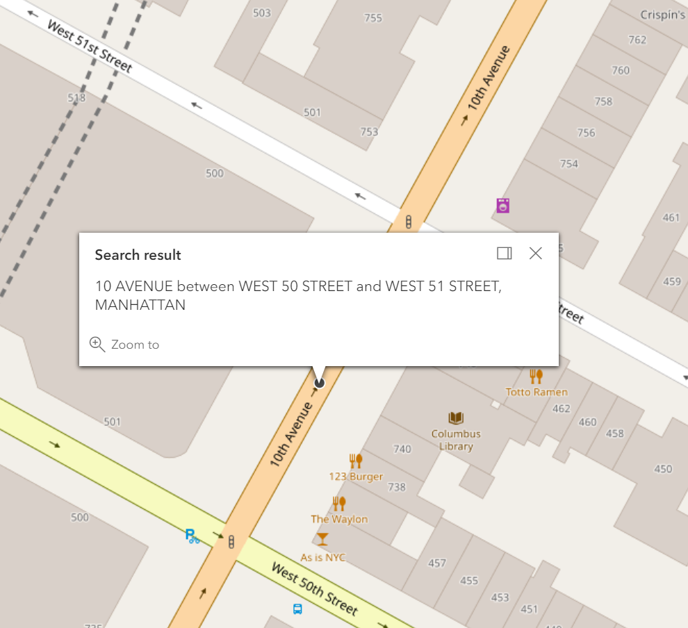
According to the NYC Geosupport User Guide (UPG), a street segment is defined as a street stretch between a pair of delimiting nodes which may not coincide with an intersecting street. A street segment can therefore consist of a set of one or more street centerline segments. In Geosupport, the general term ‘street segment’ is used to describe two situations: 1) A street segment is strictly defined as a street stretch such that the two delimiting nodes are consecutive along the ‘on’ street. Every such segment is uniquely identified by a segment ID, and 2) For Geosupport purposes, a street segment often refers to a street stretch consisting of more than one segment, such that at least one side of the street stretch is a single entire blockface. This street stretch is defined by multiple segments id’s, all of which may optionally be returned to the user.

A street segment, is considered to comprise both sides of the ‘on’ street. In the case of a street segment, each side necessarily is either a single entire blockface or a portion of one.

Example: Search for street segment along 10th Avenue (10th Ave between W 50 St and W 51 St, Manhattan)

 Request


/findAddressCandidates?singleLine=10th%20Ave%20between%20W%2050%20St%20and%20W%2051%20St%2C%20Manhattan&token=[YOUR_TOKEN]

    Or, multiline

/findAddressCandidates?onStreet=10th%20Ave&crossStreetOne=W%2050%20St&crossStreetTwo=W%2051%20St&boroughCrossStreetOne=Manhattan&boroughCrossStreetTwo=Manhattan&token=[YOUR_TOKEN]

 Response

{
  "spatialReference": {
    "wkid": 4326,
    "latestWkid": 4326
  },
  "candidates": [
    {
      "address": "10 AVENUE between WEST 50 STREET and WEST 51 STREET, MANHATTAN",
      "location": {
        "y": 40.764998,
        "x": -73.9915595
      },
      "score": 100,
      "attributes": {
        "bikeLane": "",
        "bikeLane2": "",
        "bikeTrafficDirection": "",
        "coincidentSegmentCount": "1",
        "curveFlag": "",
        "dcpPreferredLgcForStreet1": "02",
        "dcpPreferredLgcForStreet2": "01",
        "dcpPreferredLgcForStreet3": "01",
        "dotStreetLightContractorArea": "1",
        "featureTypeCode": "",
        "federalClassificationCode": "",
        "firstBoroughName": "MANHATTAN",
        "firstStreetCode": "11101002010",
        "firstStreetNameNormalized": "10 AVENUE",
        "fromLatitude": 40.764685,
        "fromLgc1": "01",
        "fromLgc2": "",
        "fromLongitude": -73.991787,
        "fromNode": "0021364",
        "fromXCoordinate": -73.991787,
        "fromYCoordinate": 40.764685,
        "generatedRecordFlag": "",
        "genericId": "0001152",
        "geosupportFunctionCode": "3",
        "geosupportReturnCode": "00",
        "highCrossStreetB5SC1": "134790",
        "latitude": 40.764998,
        "leftSegmentAssemblyDistrict": "75",
        "leftSegmentBlockFaceId": "1222601353",
        "leftSegmentBoroughCode": "1",
        "leftSegmentCensusBlock2000": "2010",
        "leftSegmentCensusBlock2010": "2008",
        "leftSegmentCensusTract1990": "135",
        "leftSegmentCensusTract2000": "135",
        "leftSegmentCensusTract2010": "135",
        "leftSegmentCommunityDistrict": "104",
        "leftSegmentCommunityDistrictBoroughCode": "1",
        "leftSegmentCommunityDistrictNumber": "04",
        "leftSegmentCommunitySchoolDistrict": "02",
        "leftSegmentDynamicBlock": "211",
        "leftSegmentElectionDistrict": "083",
        "leftSegmentFireBattalion": "09",
        "leftSegmentFireCompanyNumber": "054",
        "leftSegmentFireCompanyType": "E",
        "leftSegmentFireDivision": "03",
        "leftSegmentHealthArea": "4500",
        "leftSegmentHealthCenterDistrict": "15",
        "leftSegmentHighHouseNumber": "0000751",
        "leftSegmentInterimAssistanceEligibilityIndicator": "I",
        "leftSegmentLowHouseNumber": "0000737",
        "leftSegmentNta": "MN15",
        "leftSegmentNtaName": "Clinton",
        "leftSegmentPolicePatrolBorough": "MS",
        "leftSegmentPolicePatrolBoroughCommand": "1",
        "leftSegmentPolicePrecinct": "018",
        "leftSegmentZipCode": "10019",
        "legacyId": "0033860",
        "lgc1": "02",
        "lionBoroughCode": "1",
        "lionFaceCode": "4340",
        "lionKey": "1434000410",
        "lionSequenceNumber": "00410",
        "locationType": "MID",
        "longitude": -73.9915595,
        "lowCrossStreetB5SC1": "134770",
        "midXCoordinate": -73.9915595,
        "midYCoordinate": 40.764998,
        "numberOfCrossStreetB5SCsHighAddressEnd": "1",
        "numberOfCrossStreetB5SCsLowAddressEnd": "1",
        "numberOfStreetCodesAndNamesInList": "",
        "physicalId": "0001287",
        "rightOfWayType": "",
        "rightSegment1990CensusTract": "133",
        "rightSegment2000CensusBlock": "3001",
        "rightSegment2000CensusTract": "133",
        "rightSegment2010CensusBlock": "3001",
        "rightSegment2010CensusTract": "133",
        "rightSegmentAssemblyDistrict": "75",
        "rightSegmentBlockFaceId": "1222605191",
        "rightSegmentBoroughCode": "1",
        "rightSegmentCommunityDistrict": "104",
        "rightSegmentCommunityDistrictBoroughCode": "1",
        "rightSegmentCommunityDistrictNumber": "04",
        "rightSegmentCommunitySchoolDistrict": "02",
        "rightSegmentDynamicBlock": "301",
        "rightSegmentElectionDistrict": "083",
        "rightSegmentFireBattalion": "09",
        "rightSegmentFireCompanyNumber": "054",
        "rightSegmentFireCompanyType": "E",
        "rightSegmentFireDivision": "03",
        "rightSegmentHealthArea": "4700",
        "rightSegmentHealthCenterDistrict": "15",
        "rightSegmentHighHouseNumber": "0000748",
        "rightSegmentInterimAssistanceEligibilityIndicator": "I",
        "rightSegmentLowHouseNumber": "0000734",
        "rightSegmentNta": "MN15",
        "rightSegmentNtaName": "Clinton",
        "rightSegmentPolicePatrolBorough": "MS",
        "rightSegmentPolicePatrolBoroughCommand": "1",
        "rightSegmentPolicePrecinct": "018",
        "rightSegmentZipCode": "10019",
        "roadwayType": "1",
        "sanitationSnowPriorityCode": "C",
        "secondStreetCode": "13477001010",
        "secondStreetNameNormalized": "WEST   50 STREET",
        "segmentAzimuth": "061",
        "segmentIdentifier": "0033860",
        "segmentLengthInFeet": "00260",
        "segmentOrientation": "N",
        "segmentTypeCode": "U",
        "streetCode1": "",
        "streetCode6": "",
        "streetName1": "",
        "streetName6": "",
        "streetStatus": "2",
        "streetWidth": "58",
        "thirdStreetCode": "13479001010",
        "thirdStreetNameNormalized": "WEST   51 STREET",
        "toLatitude": 40.765311,
        "toLongitude": -73.991332,
        "toNode": "0021366",
        "toXCoordinate": -73.991332,
        "toYCoordinate": 40.765311,
        "trafficDirection": "W",
        "Match_addr": "10 AVENUE between WEST 50 STREET and WEST 51 STREET, MANHATTAN",
        "address_separated": "10 AVENUE,WEST 50 STREET,WEST 51 STREET,MANHATTAN",
        "Loc_name": "geosupport_3",
        "status": "EXACT_MATCH",
        "geoclient_function": "STREETSEGMENT",
        "geoclient_version": "2.0.0",
        "geosupport_release": "19a",
        "geosupport_release_date": "February 2019",
        "geosupport_version": "19.1",
        "level": "0"
      }
    }
  ]
}

 Map

Search street segment blockface ("on-from-to")

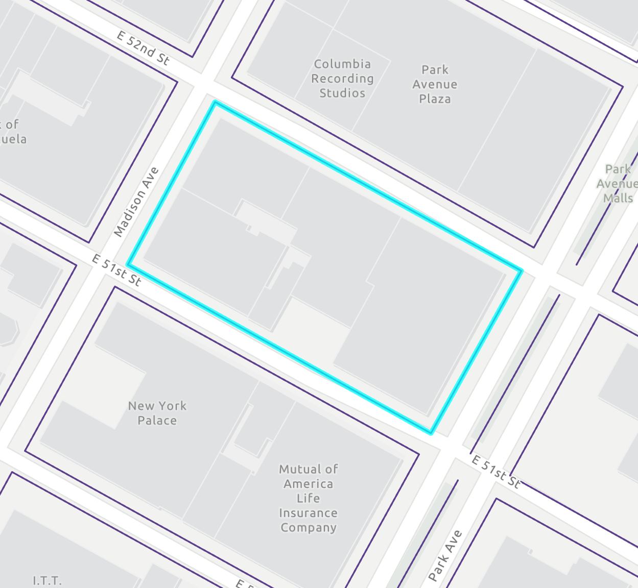
According to the NYC Geosupport User Guide (UPG), a blockface is a continuous frontage of a physical city block along one street, ignoring the presence of any bending points or other intervening nodes. That is, the portions of a street frontage of a block that lie on both sides of a bending point are considered to be parts of the same blockface.

For example, the Manhattan block bounded by Madison and Park Avenues and East 51st and East 52nd Streets has the following four blockfaces (see figure below, block is highlighted in blue): 1) The east side of Madison Avenue between East 51st and East 52nd Streets, 2) The south side of East 52nd Street between Madison and Park Avenues, 3) The west side of Park Avenue between East 51st and East 52nd Streets, 4) The north side of East 51st Street between Madison and Park Avenues

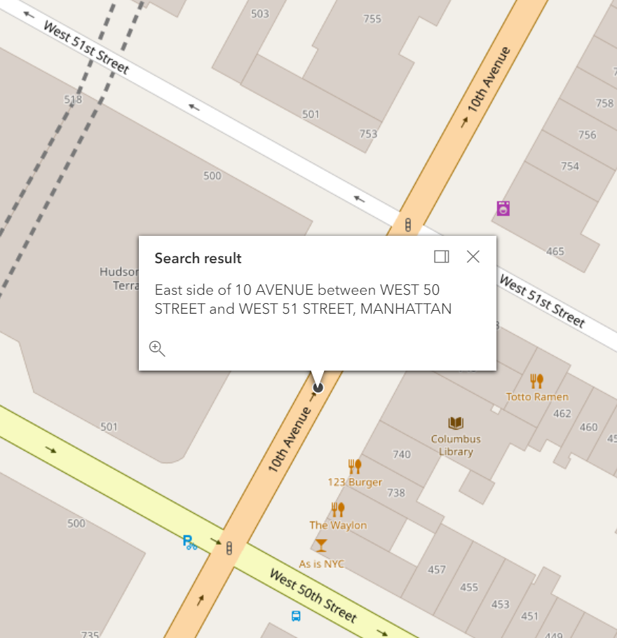
Example: Search for street segment blockface along 10th Avenue (E side of 10th Ave between W 50 St and W 51 St, Manhattan)

 Request


    Or, multiline


 Response

{
  "spatialReference": {
    "wkid": 4326,
    "latestWkid": 4326
  },
  "candidates": [
    {
      "address": "East side of 10 AVENUE between WEST 50 STREET and WEST 51 STREET, MANHATTAN",
      "location": {
        "y": 40.764998,
        "x": -73.9915595
      },
      "score": 100,
      "attributes": {
        "assemblyDistrict": "75",
        "bikeLane": "",
        "bikeLane2": "",
        "bikeTrafficDirection": "",
        "blockFaceId": "1222605191",
        "boroughCode": "1",
        "censusBlock2000": "3001",
        "censusBlock2010": "3001",
        "censusTract1990": "133",
        "censusTract2000": "133",
        "censusTract2010": "133",
        "coincidentSegmentCount": "1",
        "communityDistrict": "104",
        "communityDistrictBoroughCode": "1",
        "communityDistrictNumber": "04",
        "communitySchoolDistrict": "02",
        "curveFlag": "",
        "dcpPreferredLgcForStreet1": "02",
        "dcpPreferredLgcForStreet2": "01",
        "dcpPreferredLgcForStreet3": "01",
        "dotStreetLightContractorArea": "1",
        "electionDistrict": "083",
        "featureTypeCode": "",
        "federalClassificationCode": "",
        "fireBattalion": "09",
        "fireCompanyNumber": "054",
        "fireCompanyType": "E",
        "fireDivision": "03",
        "firstBoroughName": "MANHATTAN",
        "firstStreetCode": "11101002010",
        "firstStreetNameNormalized": "10 AVENUE",
        "fromLatitude": 40.764685,
        "fromLongitude": -73.991787,
        "fromNode": "0021364",
        "fromXCoordinate": -73.991787,
        "fromYCoordinate": 40.764685,
        "genericId": "0001152",
        "geosupportFunctionCode": "3C",
        "geosupportReturnCode": "00",
        "healthArea": "4700",
        "highHouseNumber": "0000748",
        "interimAssistanceEligibilityIndicator": "I",
        "latitude": 40.764998,
        "leftSegmentHealthCenterDistrict": "15",
        "legacySegmentId": "0033860",
        "lionBoroughCode": "1",
        "lionFaceCode": "4340",
        "lionKey": "1434000410",
        "lionSequenceNumber": "00410",
        "locationType": "MID",
        "longitude": -73.9915595,
        "lowHouseNumber": "0000734",
        "midXCoordinate": -73.9915595,
        "midYCoordinate": 40.764998,
        "nta": "MN15",
        "ntaName": "Clinton",
        "numberOfCrossStreetB5SCsHighAddressEnd": "1",
        "numberOfCrossStreetB5SCsLowAddressEnd": "1",
        "physicalId": "0001287",
        "policePatrolBorough": "MS",
        "policePatrolBoroughCommand": "1",
        "policePrecinct": "018",
        "rightOfWayType": "",
        "rightSegmentHealthCenterDistrict": "15",
        "roadwayType": "1",
        "sanitationSnowPriorityCode": "C",
        "secondStreetCode": "13477001010",
        "secondStreetNameNormalized": "WEST   50 STREET",
        "segmentAzimuth": "061",
        "segmentIdentifier": "0033860",
        "segmentLengthInFeet": "00260",
        "segmentOrientation": "N",
        "segmentTypeCode": "U",
        "sideOfStreetDirection": "East",
        "sideOfStreetIndicator": "R",
        "streetStatus": "2",
        "streetWidth": "58",
        "thirdStreetCode": "13479001010",
        "thirdStreetNameNormalized": "WEST   51 STREET",
        "toLatitude": 40.765311,
        "toLongitude": -73.991332,
        "toNode": "0021366",
        "toXCoordinate": -73.991332,
        "toYCoordinate": 40.765311,
        "trafficDirection": "W",
        "zipCode": "10019",
        "Match_addr": "East side of 10 AVENUE between WEST 50 STREET and WEST 51 STREET, MANHATTAN",
        "address_separated": "East,10 AVENUE,WEST 50 STREET,WEST 51 STREET,MANHATTAN",
        "Loc_name": "geosupport_3C",
        "status": "EXACT_MATCH",
        "geoclient_function": "BLOCKFACE",
        "geoclient_version": "2.0.0",
        "geosupport_release": "19a",
        "geosupport_release_date": "February 2019",
        "geosupport_version": "19.1",
        "level": "0"
      }
    }
  ]
}

 Map

Search for street stretches ("on-from-to")

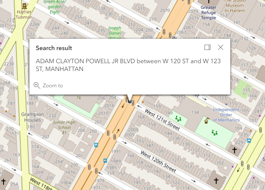
According to the NYC Geosupport User Guide (UPG), a street stretch is a portion (possibly all) of a street (called the ‘on’ street) between any two nodes along it (called the delimiting nodes of the stretch). A street stretch is considered to comprise both sides of the ‘on’ street. Every street stretch is composed of a set of one or more street segments, which do not necessarily form a continuously connected chain. That is, a street stretch can encompass gaps in the street.

For each street segment request, each REAL instersection along the stretch will be included in the response within the intersections parameter (see example below). Psuedo-intersections are not included in the list. A loction will be provided in the location object in the response, which represents an estimation of the midpoint of the street stretch. If the street stretch is non-contiguous, then no location will be provided in the response. However, the intersections will have location specified which can be used if needed.

Example: Search for street stretch along 7th Avenue, with DCP 'preferred' street names (7th Ave between W 120 St and W 123 St, Manhattan)

 Request


    Or, multiline


 Response

{
  "spatialReference": {
    "wkid": 4326,
    "latestWkid": 4326
  },
  "candidates": [
    {
      "address": "ADAM CLAYTON POWELL JR BOULEVARD between WEST 120 STREET and WEST 123 STREET, MANHATTAN",
      "location": {
        "x": -73.95019473864491,
        "y": 40.806413093105405
      },
      "score": 100,
      "attributes": {
        "boroughCode": "1",
        "firstBoroughName": "MANHATTAN",
        "firstStreetCode": "11061004010",
        "firstStreetNameNormalized": "ADAM CLAYTON POWELL JR BOULEVARD",
        "geosupportFunctionCode": "3S",
        "geosupportReturnCode": "00",
        "intersections": [
          {
            "id": 1,
            "mhriFlag": "",
            "distancePrevInt": "00000",
            "gapFlag": "",
            "nodeNumber": "0024149",
            "numStreets": "1",
            "crossStreetB7SC1": "13617002",
            "attributes": {
              "assemblyDistrict": "70",
              "cdEligibility": "E",
              "cityCouncilDistrict": "09",
              "civilCourtDistrict": "10",
              "communityDistrict": "110",
              "communityDistrictBoroughCode": "1",
              "communityDistrictNumber": "10",
              "communitySchoolDistrict": "03",
              "congressionalDistrict": "13",
              "crossStreetB5SC1": "110610",
              "crossStreetB5SC2": "136170",
              "crossStreetB5SC3": "",
              "crossStreetB5SC4": "",
              "crossStreetB5SC5": "",
              "dcpPreferredLgcForStreet1": "01",
              "dcpPreferredLgcForStreet2": "02",
              "dotStreetLightContractorArea": "1",
              "fireBattalion": "12",
              "fireCompanyNumber": "014",
              "fireCompanyType": "L",
              "fireDivision": "03",
              "firstBoroughName": "MANHATTAN",
              "firstStreetCode": "11061001100",
              "firstStreetNameNormalized": "ADAM CLAYTON POWELL JR BOULEVARD",
              "geosupportFunctionCode": "2",
              "geosupportMessage": "OUTPUT STREET NAME/CODE DIFFER FROM INPUT",
              "geosupportReturnCode": "01",
              "healthArea": "1500",
              "healthCenterDistrict": "11",
              "latitude": 40.80578474862654,
              "lionNodeNumber": "0024149",
              "longitude": -73.95065395621383,
              "nodeNumber": "",
              "numberOfIntersectingStreets": "2",
              "policePatrolBorough": "MN",
              "policePatrolBoroughCommand": "2",
              "policePrecinct": "028",
              "policeSector": "28D",
              "reasonCode": "6",
              "sanitationDistrict": "110",
              "sanitationSectionSubsection": "1A",
              "secondStreetCode": "13617002010",
              "secondStreetNameNormalized": "WEST  120 STREET",
              "segment1990CensusTract": "220",
              "segment2000CensusTract": "220",
              "segment2010CensusTract": "220",
              "stateSenatorialDistrict": "30",
              "streetCode1": "11061001",
              "streetCode10": "",
              "streetCode2": "13617002",
              "streetCode3": "",
              "streetCode4": "",
              "streetCode5": "",
              "streetCode6": "",
              "streetCode7": "",
              "streetCode8": "",
              "streetCode9": "",
              "streetName1": "ADAM CLAYTON POWELL JR BOULEVARD",
              "streetName10": "",
              "streetName2": "WEST  120 STREET",
              "streetName3": "",
              "streetName4": "",
              "streetName5": "",
              "streetName6": "",
              "streetName7": "",
              "streetName8": "",
              "streetName9": "",
              "x": -73.95065395621383,
              "y": 40.80578474862654,
              "zipCode": "10027"
            },
            "location": {
              "x": -73.95065395621383,
              "y": 40.80578474862654
            },
            "wkid": 4326
          },
          {
            "id": 2,
            "mhriFlag": "",
            "distancePrevInt": "00262",
            "gapFlag": "",
            "nodeNumber": "0024210",
            "numStreets": "1",
            "crossStreetB7SC1": "13619001",
            "attributes": {
              "assemblyDistrict": "70",
              "cdEligibility": "E",
              "cityCouncilDistrict": "09",
              "civilCourtDistrict": "10",
              "communityDistrict": "110",
              "communityDistrictBoroughCode": "1",
              "communityDistrictNumber": "10",
              "communitySchoolDistrict": "03",
              "congressionalDistrict": "13",
              "crossStreetB5SC1": "110610",
              "crossStreetB5SC2": "136190",
              "crossStreetB5SC3": "",
              "crossStreetB5SC4": "",
              "crossStreetB5SC5": "",
              "dcpPreferredLgcForStreet1": "01",
              "dcpPreferredLgcForStreet2": "01",
              "dotStreetLightContractorArea": "1",
              "fireBattalion": "12",
              "fireCompanyNumber": "014",
              "fireCompanyType": "L",
              "fireDivision": "03",
              "firstBoroughName": "MANHATTAN",
              "firstStreetCode": "11061001100",
              "firstStreetNameNormalized": "ADAM CLAYTON POWELL JR BOULEVARD",
              "geosupportFunctionCode": "2",
              "geosupportMessage": "OUTPUT STREET NAME/CODE DIFFER FROM INPUT",
              "geosupportReturnCode": "01",
              "healthArea": "1500",
              "healthCenterDistrict": "11",
              "latitude": 40.806413093105405,
              "lionNodeNumber": "0024210",
              "longitude": -73.95019473864491,
              "nodeNumber": "",
              "numberOfIntersectingStreets": "2",
              "policePatrolBorough": "MN",
              "policePatrolBoroughCommand": "2",
              "policePrecinct": "028",
              "policeSector": "28D",
              "reasonCode": "6",
              "sanitationDistrict": "110",
              "sanitationSectionSubsection": "1A",
              "secondStreetCode": "13619001010",
              "secondStreetNameNormalized": "WEST  121 STREET",
              "segment1990CensusTract": "220",
              "segment2000CensusTract": "220",
              "segment2010CensusTract": "220",
              "stateSenatorialDistrict": "30",
              "streetCode1": "11061001",
              "streetCode10": "",
              "streetCode2": "13619001",
              "streetCode3": "",
              "streetCode4": "",
              "streetCode5": "",
              "streetCode6": "",
              "streetCode7": "",
              "streetCode8": "",
              "streetCode9": "",
              "streetName1": "ADAM CLAYTON POWELL JR BOULEVARD",
              "streetName10": "",
              "streetName2": "WEST  121 STREET",
              "streetName3": "",
              "streetName4": "",
              "streetName5": "",
              "streetName6": "",
              "streetName7": "",
              "streetName8": "",
              "streetName9": "",
              "x": -73.95019473864491,
              "y": 40.806413093105405,
              "zipCode": "10027"
            },
            "location": {
              "x": -73.95019473864491,
              "y": 40.806413093105405
            },
            "wkid": 4326
          },
          {
            "id": 3,
            "mhriFlag": "",
            "distancePrevInt": "00261",
            "gapFlag": "",
            "nodeNumber": "0024211",
            "numStreets": "2",
            "crossStreetB7SC1": "13621002",
            "attributes": {
              "assemblyDistrict": "70",
              "cdEligibility": "E",
              "cityCouncilDistrict": "09",
              "civilCourtDistrict": "10",
              "communityDistrict": "110",
              "communityDistrictBoroughCode": "1",
              "communityDistrictNumber": "10",
              "communitySchoolDistrict": "03",
              "congressionalDistrict": "13",
              "crossStreetB5SC1": "110610",
              "crossStreetB5SC2": "136210",
              "crossStreetB5SC3": "100388",
              "crossStreetB5SC4": "",
              "crossStreetB5SC5": "",
              "dcpPreferredLgcForStreet1": "01",
              "dcpPreferredLgcForStreet2": "02",
              "dotStreetLightContractorArea": "1",
              "fireBattalion": "12",
              "fireCompanyNumber": "014",
              "fireCompanyType": "L",
              "fireDivision": "03",
              "firstBoroughName": "MANHATTAN",
              "firstStreetCode": "11061001100",
              "firstStreetNameNormalized": "ADAM CLAYTON POWELL JR BOULEVARD",
              "geosupportFunctionCode": "2",
              "geosupportMessage": "OUTPUT STREET NAME/CODE DIFFER FROM INPUT",
              "geosupportReturnCode": "01",
              "healthArea": "1500",
              "healthCenterDistrict": "11",
              "latitude": 40.80703869254305,
              "lionNodeNumber": "0024211",
              "longitude": -73.94973912672958,
              "nodeNumber": "",
              "numberOfIntersectingStreets": "3",
              "policePatrolBorough": "MN",
              "policePatrolBoroughCommand": "2",
              "policePrecinct": "028",
              "policeSector": "28D",
              "reasonCode": "6",
              "sanitationDistrict": "110",
              "sanitationSectionSubsection": "1A",
              "secondStreetCode": "13621002010",
              "secondStreetNameNormalized": "WEST  122 STREET",
              "segment1990CensusTract": "220",
              "segment2000CensusTract": "220",
              "segment2010CensusTract": "220",
              "stateSenatorialDistrict": "30",
              "streetCode1": "11061001",
              "streetCode10": "",
              "streetCode2": "13621002",
              "streetCode3": "10038801",
              "streetCode4": "",
              "streetCode5": "",
              "streetCode6": "",
              "streetCode7": "",
              "streetCode8": "",
              "streetCode9": "",
              "streetName1": "ADAM CLAYTON POWELL JR BOULEVARD",
              "streetName10": "",
              "streetName2": "WEST  122 STREET",
              "streetName3": "HERMENA ROWE STREET",
              "streetName4": "",
              "streetName5": "",
              "streetName6": "",
              "streetName7": "",
              "streetName8": "",
              "streetName9": "",
              "x": -73.94973912672958,
              "y": 40.80703869254305,
              "zipCode": "10027"
            },
            "location": {
              "x": -73.94973912672958,
              "y": 40.80703869254305
            },
            "wkid": 4326
          },
          {
            "id": 4,
            "mhriFlag": "",
            "distancePrevInt": "00262",
            "gapFlag": "",
            "nodeNumber": "0024212",
            "numStreets": "1",
            "crossStreetB7SC1": "13623001",
            "attributes": {
              "assemblyDistrict": "70",
              "cdEligibility": "I",
              "cityCouncilDistrict": "09",
              "civilCourtDistrict": "10",
              "communityDistrict": "110",
              "communityDistrictBoroughCode": "1",
              "communityDistrictNumber": "10",
              "communitySchoolDistrict": "05",
              "congressionalDistrict": "13",
              "crossStreetB5SC1": "110610",
              "crossStreetB5SC2": "136230",
              "crossStreetB5SC3": "",
              "crossStreetB5SC4": "",
              "crossStreetB5SC5": "",
              "dcpPreferredLgcForStreet1": "01",
              "dcpPreferredLgcForStreet2": "01",
              "dotStreetLightContractorArea": "1",
              "fireBattalion": "12",
              "fireCompanyNumber": "014",
              "fireCompanyType": "L",
              "fireDivision": "03",
              "firstBoroughName": "MANHATTAN",
              "firstStreetCode": "11061001100",
              "firstStreetNameNormalized": "ADAM CLAYTON POWELL JR BOULEVARD",
              "geosupportFunctionCode": "2",
              "geosupportMessage": "OUTPUT STREET NAME/CODE DIFFER FROM INPUT",
              "geosupportReturnCode": "01",
              "healthArea": "1500",
              "healthCenterDistrict": "11",
              "latitude": 40.807667033251064,
              "lionNodeNumber": "0024212",
              "longitude": -73.94927989187288,
              "nodeNumber": "",
              "numberOfIntersectingStreets": "2",
              "policePatrolBorough": "MN",
              "policePatrolBoroughCommand": "2",
              "policePrecinct": "028",
              "policeSector": "28D",
              "reasonCode": "6",
              "sanitationDistrict": "110",
              "sanitationSectionSubsection": "1A",
              "secondStreetCode": "13623001010",
              "secondStreetNameNormalized": "WEST  123 STREET",
              "segment1990CensusTract": "222",
              "segment2000CensusTract": "222",
              "segment2010CensusTract": "222",
              "stateSenatorialDistrict": "30",
              "streetCode1": "11061001",
              "streetCode10": "",
              "streetCode2": "13623001",
              "streetCode3": "",
              "streetCode4": "",
              "streetCode5": "",
              "streetCode6": "",
              "streetCode7": "",
              "streetCode8": "",
              "streetCode9": "",
              "streetName1": "ADAM CLAYTON POWELL JR BOULEVARD",
              "streetName10": "",
              "streetName2": "WEST  123 STREET",
              "streetName3": "",
              "streetName4": "",
              "streetName5": "",
              "streetName6": "",
              "streetName7": "",
              "streetName8": "",
              "streetName9": "",
              "x": -73.94927989187288,
              "y": 40.807667033251064,
              "zipCode": "10027"
            },
            "location": {
              "x": -73.94927989187288,
              "y": 40.807667033251064
            },
            "wkid": 4326
          }
        ],
        "latitude": 40.806413093105405,
        "lgc": "04",
        "longitude": -73.95019473864491,
        "numberOfIntersections": "004",
        "numberOfStreetCodesAndNamesInList": "",
        "reasonCode": "",
        "secondStreetCode": "13617002010",
        "secondStreetNameNormalized": "WEST  120 STREET",
        "streetCode": "10610",
        "thirdStreetCode": "13623001010",
        "thirdStreetNameNormalized": "WEST  123 STREET",
        "x": -73.95019473864491,
        "y": 40.806413093105405,
        "Match_addr": "ADAM CLAYTON POWELL JR BOULEVARD between WEST 120 STREET and WEST 123 STREET, MANHATTAN",
        "address_separated": "ADAM CLAYTON POWELL JR BOULEVARD,WEST 120 STREET,WEST 123 STREET,MANHATTAN",
        "Loc_name": "geosupport_3S",
        "status": "EXACT_MATCH",
        "geoclient_function": "STREETSTRETCH",
        "geoclient_version": "2.0.0",
        "geosupport_release": "19a",
        "geosupport_release_date": "February 2019",
        "geosupport_version": "19.1",
        "level": "0"
      }
    }
  ]
}

 Map

Example: Search for street stretch that ends in a dead end (west 61 street between west end ave and dead end, manhattan)

 Request


    Or, multiline


 Response

{
  "spatialReference": {
    "wkid": 4326,
    "latestWkid": 4326
  },
  "candidates": [
    {
      "address": "WEST 61 STREET between DEAD END and WEST END AVENUE, MANHATTAN",
      "location": {
        "x": -73.98669592202735,
        "y": 40.77166929180413
      },
      "score": 100,
      "attributes": {
        "boroughCode": "1",
        "firstBoroughName": "MANHATTAN",
        "firstStreetCode": "13499001010",
        "firstStreetNameNormalized": "WEST   61 STREET",
        "geosupportFunctionCode": "3S",
        "geosupportReturnCode": "00",
        "intersections": [
          {
            "id": 1,
            "mhriFlag": "",
            "distancePrevInt": "00000",
            "gapFlag": "",
            "nodeNumber": "0021656",
            "numStreets": "1",
            "crossStreetB7SC1": "11640001",
            "attributes": {
              "assemblyDistrict": "67",
              "cdEligibility": "I",
              "cityCouncilDistrict": "03",
              "civilCourtDistrict": "03",
              "communityDistrict": "107",
              "communityDistrictBoroughCode": "1",
              "communityDistrictNumber": "07",
              "communitySchoolDistrict": "03",
              "congressionalDistrict": "10",
              "crossStreetB5SC1": "116400",
              "crossStreetB5SC2": "134990",
              "crossStreetB5SC3": "",
              "crossStreetB5SC4": "",
              "crossStreetB5SC5": "",
              "dcpPreferredLgcForStreet1": "01",
              "dcpPreferredLgcForStreet2": "01",
              "dotStreetLightContractorArea": "1",
              "fireBattalion": "09",
              "fireCompanyNumber": "040",
              "fireCompanyType": "E",
              "fireDivision": "03",
              "firstBoroughName": "MANHATTAN",
              "firstStreetCode": "13499001010",
              "firstStreetNameNormalized": "WEST   61 STREET",
              "geosupportFunctionCode": "2",
              "geosupportReturnCode": "00",
              "healthArea": "4600",
              "healthCenterDistrict": "15",
              "latitude": 40.77132335847631,
              "lionNodeNumber": "0021656",
              "longitude": -73.98588728068509,
              "nodeNumber": "",
              "numberOfIntersectingStreets": "2",
              "policePatrolBorough": "MN",
              "policePatrolBoroughCommand": "2",
              "policePrecinct": "020",
              "policeSector": "20A",
              "reasonCode": "",
              "sanitationDistrict": "107",
              "sanitationSectionSubsection": "1A",
              "secondStreetCode": "11640001010",
              "secondStreetNameNormalized": "DEAD END",
              "segment1990CensusTract": "145",
              "segment2000CensusTract": "145",
              "segment2010CensusTract": "145",
              "stateSenatorialDistrict": "27",
              "streetCode1": "11640001",
              "streetCode10": "",
              "streetCode2": "13499001",
              "streetCode3": "",
              "streetCode4": "",
              "streetCode5": "",
              "streetCode6": "",
              "streetCode7": "",
              "streetCode8": "",
              "streetCode9": "",
              "streetName1": "WEST   61 STREET",
              "streetName10": "",
              "streetName2": "DEAD END",
              "streetName3": "",
              "streetName4": "",
              "streetName5": "",
              "streetName6": "",
              "streetName7": "",
              "streetName8": "",
              "streetName9": "",
              "x": -73.98588728068509,
              "y": 40.77132335847631,
              "zipCode": "10023"
            },
            "location": {
              "x": -73.98588728068509,
              "y": 40.77132335847631
            },
            "wkid": 4326
          },
          {
            "id": 2,
            "mhriFlag": "",
            "distancePrevInt": "00257",
            "gapFlag": "",
            "nodeNumber": "0021624",
            "numStreets": "1",
            "crossStreetB7SC1": "11171001",
            "attributes": {
              "assemblyDistrict": "67",
              "cdEligibility": "I",
              "cityCouncilDistrict": "03",
              "civilCourtDistrict": "03",
              "communityDistrict": "107",
              "communityDistrictBoroughCode": "1",
              "communityDistrictNumber": "07",
              "communitySchoolDistrict": "03",
              "congressionalDistrict": "10",
              "crossStreetB5SC1": "111710",
              "crossStreetB5SC2": "134990",
              "crossStreetB5SC3": "",
              "crossStreetB5SC4": "",
              "crossStreetB5SC5": "",
              "dcpPreferredLgcForStreet1": "01",
              "dcpPreferredLgcForStreet2": "01",
              "dotStreetLightContractorArea": "1",
              "fireBattalion": "09",
              "fireCompanyNumber": "040",
              "fireCompanyType": "E",
              "fireDivision": "03",
              "firstBoroughName": "MANHATTAN",
              "firstStreetCode": "13499001010",
              "firstStreetNameNormalized": "WEST   61 STREET",
              "geosupportFunctionCode": "2",
              "geosupportReturnCode": "00",
              "healthArea": "4600",
              "healthCenterDistrict": "15",
              "latitude": 40.77166929180413,
              "lionNodeNumber": "0021624",
              "longitude": -73.98669592202735,
              "nodeNumber": "",
              "numberOfIntersectingStreets": "2",
              "policePatrolBorough": "MN",
              "policePatrolBoroughCommand": "2",
              "policePrecinct": "020",
              "policeSector": "20A",
              "reasonCode": "",
              "sanitationDistrict": "107",
              "sanitationSectionSubsection": "1A",
              "secondStreetCode": "11171001010",
              "secondStreetNameNormalized": "AMSTERDAM AVENUE",
              "segment1990CensusTract": "145",
              "segment2000CensusTract": "145",
              "segment2010CensusTract": "145",
              "stateSenatorialDistrict": "27",
              "streetCode1": "11171001",
              "streetCode10": "",
              "streetCode2": "13499001",
              "streetCode3": "",
              "streetCode4": "",
              "streetCode5": "",
              "streetCode6": "",
              "streetCode7": "",
              "streetCode8": "",
              "streetCode9": "",
              "streetName1": "WEST   61 STREET",
              "streetName10": "",
              "streetName2": "AMSTERDAM AVENUE",
              "streetName3": "",
              "streetName4": "",
              "streetName5": "",
              "streetName6": "",
              "streetName7": "",
              "streetName8": "",
              "streetName9": "",
              "x": -73.98669592202735,
              "y": 40.77166929180413,
              "zipCode": "10023"
            },
            "location": {
              "x": -73.98669592202735,
              "y": 40.77166929180413
            },
            "wkid": 4326
          },
          {
            "id": 3,
            "mhriFlag": "",
            "distancePrevInt": "00900",
            "gapFlag": "C",
            "nodeNumber": "0021619",
            "numStreets": "1",
            "crossStreetB7SC1": "14499001",
            "attributes": {
              "assemblyDistrict": "67",
              "cdEligibility": "I",
              "cityCouncilDistrict": "06",
              "civilCourtDistrict": "03",
              "communityDistrict": "107",
              "communityDistrictBoroughCode": "1",
              "communityDistrictNumber": "07",
              "communitySchoolDistrict": "03",
              "congressionalDistrict": "10",
              "crossStreetB5SC1": "134990",
              "crossStreetB5SC2": "144990",
              "crossStreetB5SC3": "",
              "crossStreetB5SC4": "",
              "crossStreetB5SC5": "",
              "dcpPreferredLgcForStreet1": "01",
              "dcpPreferredLgcForStreet2": "01",
              "dotStreetLightContractorArea": "1",
              "fireBattalion": "09",
              "fireCompanyNumber": "040",
              "fireCompanyType": "E",
              "fireDivision": "03",
              "firstBoroughName": "MANHATTAN",
              "firstStreetCode": "13499001010",
              "firstStreetNameNormalized": "WEST   61 STREET",
              "geosupportFunctionCode": "2",
              "geosupportReturnCode": "00",
              "healthArea": "3900",
              "healthCenterDistrict": "15",
              "latitude": 40.77286354617083,
              "lionNodeNumber": "0021619",
              "longitude": -73.98953706666731,
              "nodeNumber": "",
              "numberOfIntersectingStreets": "2",
              "policePatrolBorough": "MN",
              "policePatrolBoroughCommand": "2",
              "policePrecinct": "020",
              "policeSector": "20A",
              "reasonCode": "",
              "sanitationDistrict": "107",
              "sanitationSectionSubsection": "1B",
              "secondStreetCode": "14499001010",
              "secondStreetNameNormalized": "WEST END AVENUE",
              "segment1990CensusTract": "147",
              "segment2000CensusTract": "147",
              "segment2010CensusTract": "147",
              "stateSenatorialDistrict": "27",
              "streetCode1": "13499001",
              "streetCode10": "",
              "streetCode2": "14499001",
              "streetCode3": "",
              "streetCode4": "",
              "streetCode5": "",
              "streetCode6": "",
              "streetCode7": "",
              "streetCode8": "",
              "streetCode9": "",
              "streetName1": "WEST   61 STREET",
              "streetName10": "",
              "streetName2": "WEST END AVENUE",
              "streetName3": "",
              "streetName4": "",
              "streetName5": "",
              "streetName6": "",
              "streetName7": "",
              "streetName8": "",
              "streetName9": "",
              "x": -73.98953706666731,
              "y": 40.77286354617083,
              "zipCode": "10023"
            },
            "location": {
              "x": -73.98953706666731,
              "y": 40.77286354617083
            },
            "wkid": 4326
          }
        ],
        "latitude": 40.77166929180413,
        "lgc": "01",
        "longitude": -73.98669592202735,
        "numberOfIntersections": "003",
        "numberOfStreetCodesAndNamesInList": "",
        "reasonCode": "",
        "secondStreetCode": "14499001010",
        "secondStreetNameNormalized": "DEAD END",
        "streetCode": "34990",
        "thirdStreetCode": "11640001010",
        "thirdStreetNameNormalized": "WEST END AVENUE",
        "x": -73.98669592202735,
        "y": 40.77166929180413,
        "Match_addr": "WEST 61 STREET between DEAD END and WEST END AVENUE, MANHATTAN",
        "address_separated": "WEST 61 STREET,DEAD END,WEST END AVENUE,MANHATTAN",
        "Loc_name": "geosupport_3S",
        "status": "EXACT_MATCH",
        "geoclient_function": "STREETSTRETCH",
        "geoclient_version": "2.0.0",
        "geosupport_release": "19a",
        "geosupport_release_date": "February 2019",
        "geosupport_version": "19.1",
        "level": "0"
      }
    }
  ]
}

 Map

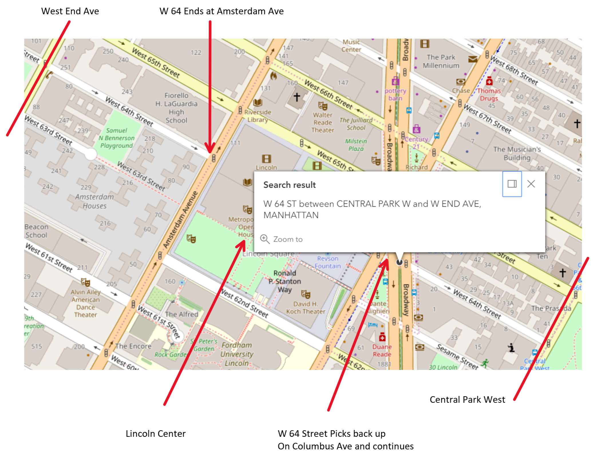
Example: Search for non-contiguous (i.e. disconnected) street stretch. W 64th street is broken by the Lincoln Center. (w 64 st between central park west and west end avenue, manhattan)

 Request


    Or, multiline


 Response

{
  "spatialReference": {
    "wkid": 4326,
    "latestWkid": 4326
  },
  "candidates": [
    {
      "address": "WEST 64 STREET between CENTRAL PARK WEST and WEST END AVENUE, MANHATTAN",
      "location": {
        "x": -73.9821792505651,
        "y": 40.772209395325504
      },
      "score": 100,
      "attributes": {
        "boroughCode": "1",
        "firstBoroughName": "MANHATTAN",
        "firstStreetCode": "13505001010",
        "firstStreetNameNormalized": "WEST   64 STREET",
        "geosupportFunctionCode": "3S",
        "geosupportReturnCode": "00",
        "intersections": [
          {
            "id": 1,
            "mhriFlag": "",
            "distancePrevInt": "00000",
            "gapFlag": "",
            "nodeNumber": "0021713",
            "numStreets": "1",
            "crossStreetB7SC1": "11451001",
            "attributes": {
              "assemblyDistrict": "75",
              "cdEligibility": "I",
              "cityCouncilDistrict": "06",
              "civilCourtDistrict": "03",
              "communityDistrict": "107",
              "communityDistrictBoroughCode": "1",
              "communityDistrictNumber": "07",
              "communitySchoolDistrict": "03",
              "congressionalDistrict": "10",
              "crossStreetB5SC1": "114510",
              "crossStreetB5SC2": "135050",
              "crossStreetB5SC3": "",
              "crossStreetB5SC4": "",
              "crossStreetB5SC5": "",
              "dcpPreferredLgcForStreet1": "01",
              "dcpPreferredLgcForStreet2": "01",
              "dotStreetLightContractorArea": "1",
              "fireBattalion": "09",
              "fireCompanyNumber": "035",
              "fireCompanyType": "L",
              "fireDivision": "03",
              "firstBoroughName": "MANHATTAN",
              "firstStreetCode": "13505001010",
              "firstStreetNameNormalized": "WEST   64 STREET",
              "geosupportFunctionCode": "2",
              "geosupportReturnCode": "00",
              "healthArea": "4000",
              "healthCenterDistrict": "15",
              "latitude": 40.77115499701191,
              "lionNodeNumber": "0021713",
              "longitude": -73.97965231891882,
              "nodeNumber": "",
              "numberOfIntersectingStreets": "2",
              "policePatrolBorough": "MN",
              "policePatrolBoroughCommand": "2",
              "policePrecinct": "020",
              "policeSector": "20A",
              "reasonCode": "",
              "sanitationDistrict": "107",
              "sanitationSectionSubsection": "1A",
              "secondStreetCode": "11451001010",
              "secondStreetNameNormalized": "CENTRAL PARK WEST",
              "segment1990CensusTract": "149",
              "segment2000CensusTract": "149",
              "segment2010CensusTract": "149",
              "stateSenatorialDistrict": "27",
              "streetCode1": "11451001",
              "streetCode10": "",
              "streetCode2": "13505001",
              "streetCode3": "",
              "streetCode4": "",
              "streetCode5": "",
              "streetCode6": "",
              "streetCode7": "",
              "streetCode8": "",
              "streetCode9": "",
              "streetName1": "WEST   64 STREET",
              "streetName10": "",
              "streetName2": "CENTRAL PARK WEST",
              "streetName3": "",
              "streetName4": "",
              "streetName5": "",
              "streetName6": "",
              "streetName7": "",
              "streetName8": "",
              "streetName9": "",
              "x": -73.97965231891882,
              "y": 40.77115499701191,
              "zipCode": "10023"
            },
            "location": {
              "x": -73.97965231891882,
              "y": 40.77115499701191
            },
            "wkid": 4326
          },
          {
            "id": 2,
            "mhriFlag": "",
            "distancePrevInt": "00798",
            "gapFlag": "C",
            "nodeNumber": "0021708",
            "numStreets": "1",
            "crossStreetB7SC1": "11361001",
            "attributes": {
              "assemblyDistrict": "75",
              "cdEligibility": "I",
              "cityCouncilDistrict": "06",
              "civilCourtDistrict": "03",
              "communityDistrict": "107",
              "communityDistrictBoroughCode": "1",
              "communityDistrictNumber": "07",
              "communitySchoolDistrict": "03",
              "congressionalDistrict": "10",
              "crossStreetB5SC1": "113610",
              "crossStreetB5SC2": "135050",
              "crossStreetB5SC3": "",
              "crossStreetB5SC4": "",
              "crossStreetB5SC5": "",
              "dcpPreferredLgcForStreet1": "01",
              "dcpPreferredLgcForStreet2": "01",
              "dotStreetLightContractorArea": "1",
              "fireBattalion": "09",
              "fireCompanyNumber": "035",
              "fireCompanyType": "L",
              "fireDivision": "03",
              "firstBoroughName": "MANHATTAN",
              "firstStreetCode": "13505001010",
              "firstStreetNameNormalized": "WEST   64 STREET",
              "geosupportFunctionCode": "2",
              "geosupportReturnCode": "00",
              "healthArea": "4000",
              "healthCenterDistrict": "15",
              "latitude": 40.772209395325504,
              "lionNodeNumber": "0021708",
              "longitude": -73.9821792505651,
              "nodeNumber": "",
              "numberOfIntersectingStreets": "2",
              "policePatrolBorough": "MN",
              "policePatrolBoroughCommand": "2",
              "policePrecinct": "020",
              "policeSector": "20A",
              "reasonCode": "",
              "sanitationDistrict": "107",
              "sanitationSectionSubsection": "1A",
              "secondStreetCode": "11361001010",
              "secondStreetNameNormalized": "BROADWAY",
              "segment1990CensusTract": "149",
              "segment2000CensusTract": "149",
              "segment2010CensusTract": "149",
              "stateSenatorialDistrict": "27",
              "streetCode1": "11361001",
              "streetCode10": "",
              "streetCode2": "13505001",
              "streetCode3": "",
              "streetCode4": "",
              "streetCode5": "",
              "streetCode6": "",
              "streetCode7": "",
              "streetCode8": "",
              "streetCode9": "",
              "streetName1": "WEST   64 STREET",
              "streetName10": "",
              "streetName2": "BROADWAY",
              "streetName3": "",
              "streetName4": "",
              "streetName5": "",
              "streetName6": "",
              "streetName7": "",
              "streetName8": "",
              "streetName9": "",
              "x": -73.9821792505651,
              "y": 40.772209395325504,
              "zipCode": "10023"
            },
            "location": {
              "x": -73.9821792505651,
              "y": 40.772209395325504
            },
            "wkid": 4326
          },
          {
            "id": 3,
            "mhriFlag": "",
            "distancePrevInt": "00996",
            "gapFlag": "G",
            "nodeNumber": "0021659",
            "numStreets": "1",
            "crossStreetB7SC1": "11171001",
            "attributes": {
              "assemblyDistrict": "67",
              "cdEligibility": "I",
              "cityCouncilDistrict": "06",
              "civilCourtDistrict": "03",
              "communityDistrict": "107",
              "communityDistrictBoroughCode": "1",
              "communityDistrictNumber": "07",
              "communitySchoolDistrict": "03",
              "congressionalDistrict": "10",
              "crossStreetB5SC1": "111710",
              "crossStreetB5SC2": "135050",
              "crossStreetB5SC3": "",
              "crossStreetB5SC4": "",
              "crossStreetB5SC5": "",
              "dcpPreferredLgcForStreet1": "01",
              "dcpPreferredLgcForStreet2": "01",
              "dotStreetLightContractorArea": "1",
              "fireBattalion": "09",
              "fireCompanyNumber": "035",
              "fireCompanyType": "L",
              "fireDivision": "03",
              "firstBoroughName": "MANHATTAN",
              "firstStreetCode": "13505001010",
              "firstStreetNameNormalized": "WEST   64 STREET",
              "geosupportFunctionCode": "2",
              "geosupportReturnCode": "00",
              "healthArea": "4000",
              "healthCenterDistrict": "15",
              "latitude": 40.77353005886806,
              "lionNodeNumber": "0021659",
              "longitude": -73.98533080617457,
              "nodeNumber": "",
              "numberOfIntersectingStreets": "2",
              "policePatrolBorough": "MN",
              "policePatrolBoroughCommand": "2",
              "policePrecinct": "020",
              "policeSector": "20A",
              "reasonCode": "",
              "sanitationDistrict": "107",
              "sanitationSectionSubsection": "1B",
              "secondStreetCode": "11171001010",
              "secondStreetNameNormalized": "AMSTERDAM AVENUE",
              "segment1990CensusTract": "149",
              "segment2000CensusTract": "149",
              "segment2010CensusTract": "149",
              "stateSenatorialDistrict": "31",
              "streetCode1": "11171001",
              "streetCode10": "",
              "streetCode2": "13505001",
              "streetCode3": "",
              "streetCode4": "",
              "streetCode5": "",
              "streetCode6": "",
              "streetCode7": "",
              "streetCode8": "",
              "streetCode9": "",
              "streetName1": "WEST   64 STREET",
              "streetName10": "",
              "streetName2": "AMSTERDAM AVENUE",
              "streetName3": "",
              "streetName4": "",
              "streetName5": "",
              "streetName6": "",
              "streetName7": "",
              "streetName8": "",
              "streetName9": "",
              "x": -73.98533080617457,
              "y": 40.77353005886806,
              "zipCode": "10023"
            },
            "location": {
              "x": -73.98533080617457,
              "y": 40.77353005886806
            },
            "wkid": 4326
          },
          {
            "id": 4,
            "mhriFlag": "",
            "distancePrevInt": "00901",
            "gapFlag": "C",
            "nodeNumber": "0021627",
            "numStreets": "1",
            "crossStreetB7SC1": "14499001",
            "attributes": {
              "assemblyDistrict": "67",
              "cdEligibility": "I",
              "cityCouncilDistrict": "06",
              "civilCourtDistrict": "03",
              "communityDistrict": "107",
              "communityDistrictBoroughCode": "1",
              "communityDistrictNumber": "07",
              "communitySchoolDistrict": "03",
              "congressionalDistrict": "10",
              "crossStreetB5SC1": "135050",
              "crossStreetB5SC2": "144990",
              "crossStreetB5SC3": "",
              "crossStreetB5SC4": "",
              "crossStreetB5SC5": "",
              "dcpPreferredLgcForStreet1": "01",
              "dcpPreferredLgcForStreet2": "01",
              "dotStreetLightContractorArea": "1",
              "fireBattalion": "09",
              "fireCompanyNumber": "035",
              "fireCompanyType": "L",
              "fireDivision": "03",
              "firstBoroughName": "MANHATTAN",
              "firstStreetCode": "13505001010",
              "firstStreetNameNormalized": "WEST   64 STREET",
              "geosupportFunctionCode": "2",
              "geosupportReturnCode": "00",
              "healthArea": "3900",
              "healthCenterDistrict": "15",
              "latitude": 40.774735325881224,
              "lionNodeNumber": "0021627",
              "longitude": -73.98817561427168,
              "nodeNumber": "",
              "numberOfIntersectingStreets": "2",
              "policePatrolBorough": "MN",
              "policePatrolBoroughCommand": "2",
              "policePrecinct": "020",
              "policeSector": "20A",
              "reasonCode": "",
              "sanitationDistrict": "107",
              "sanitationSectionSubsection": "1B",
              "secondStreetCode": "14499001010",
              "secondStreetNameNormalized": "WEST END AVENUE",
              "segment1990CensusTract": "151",
              "segment2000CensusTract": "151",
              "segment2010CensusTract": "151",
              "stateSenatorialDistrict": "31",
              "streetCode1": "13505001",
              "streetCode10": "",
              "streetCode2": "14499001",
              "streetCode3": "",
              "streetCode4": "",
              "streetCode5": "",
              "streetCode6": "",
              "streetCode7": "",
              "streetCode8": "",
              "streetCode9": "",
              "streetName1": "WEST   64 STREET",
              "streetName10": "",
              "streetName2": "WEST END AVENUE",
              "streetName3": "",
              "streetName4": "",
              "streetName5": "",
              "streetName6": "",
              "streetName7": "",
              "streetName8": "",
              "streetName9": "",
              "x": -73.98817561427168,
              "y": 40.774735325881224,
              "zipCode": "10023"
            },
            "location": {
              "x": -73.98817561427168,
              "y": 40.774735325881224
            },
            "wkid": 4326
          }
        ],
        "latitude": 40.772209395325504,
        "lgc": "01",
        "longitude": -73.9821792505651,
        "numberOfIntersections": "004",
        "numberOfStreetCodesAndNamesInList": "",
        "reasonCode": "",
        "secondStreetCode": "11451001010",
        "secondStreetNameNormalized": "CENTRAL PARK WEST",
        "streetCode": "35050",
        "thirdStreetCode": "14499001010",
        "thirdStreetNameNormalized": "WEST END AVENUE",
        "x": -73.9821792505651,
        "y": 40.772209395325504,
        "Match_addr": "WEST 64 STREET between CENTRAL PARK WEST and WEST END AVENUE, MANHATTAN",
        "address_separated": "WEST 64 STREET,CENTRAL PARK WEST,WEST END AVENUE,MANHATTAN",
        "Loc_name": "geosupport_3S",
        "status": "EXACT_MATCH",
        "geoclient_function": "STREETSTRETCH",
        "geoclient_version": "2.0.0",
        "geosupport_release": "19a",
        "geosupport_release_date": "February 2019",
        "geosupport_version": "19.1",
        "level": "0"
      }
    }
  ]
}

 Map

Example: Search for a street stretch with no FROM or TO streets (i.e. the entire street stretch). (W 76 Street, Manhattan)

 Request


    Or, multiline


 Response

{
  "spatialReference": {
    "wkid": 4326,
    "latestWkid": 4326
  },
  "candidates": [
    {
      "address": "WEST 76 STREET between CENTRAL PARK WEST and RIVERSIDE DRIVE, MANHATTAN",
      "location": {
        "x": -73.97974674370124,
        "y": 40.78119526215693
      },
      "score": 100,
      "attributes": {
        "boroughCode": "1",
        "firstBoroughName": "MANHATTAN",
        "firstStreetCode": "13529001010",
        "firstStreetNameNormalized": "WEST   76 STREET",
        "geosupportFunctionCode": "3S",
        "geosupportReturnCode": "00",
        "intersections": [
          {
            "id": 1,
            "mhriFlag": "",
            "distancePrevInt": "00000",
            "gapFlag": "",
            "nodeNumber": "0023335",
            "numStreets": "1",
            "crossStreetB7SC1": "11451001",
            "attributes": {
              "assemblyDistrict": "67",
              "cdEligibility": "I",
              "cityCouncilDistrict": "06",
              "civilCourtDistrict": "05",
              "communityDistrict": "107",
              "communityDistrictBoroughCode": "1",
              "communityDistrictNumber": "07",
              "communitySchoolDistrict": "03",
              "congressionalDistrict": "10",
              "crossStreetB5SC1": "114510",
              "crossStreetB5SC2": "135290",
              "crossStreetB5SC3": "",
              "crossStreetB5SC4": "",
              "crossStreetB5SC5": "",
              "dcpPreferredLgcForStreet1": "01",
              "dcpPreferredLgcForStreet2": "01",
              "dotStreetLightContractorArea": "1",
              "fireBattalion": "11",
              "fireCompanyNumber": "025",
              "fireCompanyType": "L",
              "fireDivision": "03",
              "firstBoroughName": "MANHATTAN",
              "firstStreetCode": "13529001010",
              "firstStreetNameNormalized": "WEST   76 STREET",
              "geosupportFunctionCode": "2",
              "geosupportReturnCode": "00",
              "healthArea": "3500",
              "healthCenterDistrict": "16",
              "latitude": 40.77880620417648,
              "lionNodeNumber": "0023335",
              "longitude": -73.97406780731409,
              "nodeNumber": "",
              "numberOfIntersectingStreets": "2",
              "policePatrolBorough": "MN",
              "policePatrolBoroughCommand": "2",
              "policePrecinct": "020",
              "policeSector": "20B",
              "reasonCode": "",
              "sanitationDistrict": "107",
              "sanitationSectionSubsection": "2A",
              "secondStreetCode": "11451001010",
              "secondStreetNameNormalized": "CENTRAL PARK WEST",
              "segment1990CensusTract": "161",
              "segment2000CensusTract": "161",
              "segment2010CensusTract": "161",
              "stateSenatorialDistrict": "29",
              "streetCode1": "11451001",
              "streetCode10": "",
              "streetCode2": "13529001",
              "streetCode3": "",
              "streetCode4": "",
              "streetCode5": "",
              "streetCode6": "",
              "streetCode7": "",
              "streetCode8": "",
              "streetCode9": "",
              "streetName1": "WEST   76 STREET",
              "streetName10": "",
              "streetName2": "CENTRAL PARK WEST",
              "streetName3": "",
              "streetName4": "",
              "streetName5": "",
              "streetName6": "",
              "streetName7": "",
              "streetName8": "",
              "streetName9": "",
              "x": -73.97406780731409,
              "y": 40.77880620417648,
              "zipCode": "10024"
            },
            "location": {
              "x": -73.97406780731409,
              "y": 40.77880620417648
            },
            "wkid": 4326
          },
          {
            "id": 2,
            "mhriFlag": "",
            "distancePrevInt": "00898",
            "gapFlag": "",
            "nodeNumber": "0023268",
            "numStreets": "1",
            "crossStreetB7SC1": "11571001",
            "attributes": {
              "assemblyDistrict": "67",
              "cdEligibility": "I",
              "cityCouncilDistrict": "06",
              "civilCourtDistrict": "05",
              "communityDistrict": "107",
              "communityDistrictBoroughCode": "1",
              "communityDistrictNumber": "07",
              "communitySchoolDistrict": "03",
              "congressionalDistrict": "10",
              "crossStreetB5SC1": "115710",
              "crossStreetB5SC2": "135290",
              "crossStreetB5SC3": "",
              "crossStreetB5SC4": "",
              "crossStreetB5SC5": "",
              "dcpPreferredLgcForStreet1": "01",
              "dcpPreferredLgcForStreet2": "01",
              "dotStreetLightContractorArea": "1",
              "fireBattalion": "11",
              "fireCompanyNumber": "025",
              "fireCompanyType": "L",
              "fireDivision": "03",
              "firstBoroughName": "MANHATTAN",
              "firstStreetCode": "13529001010",
              "firstStreetNameNormalized": "WEST   76 STREET",
              "geosupportFunctionCode": "2",
              "geosupportReturnCode": "00",
              "healthArea": "3500",
              "healthCenterDistrict": "16",
              "latitude": 40.779998022437326,
              "lionNodeNumber": "0023268",
              "longitude": -73.97690180934424,
              "nodeNumber": "",
              "numberOfIntersectingStreets": "2",
              "policePatrolBorough": "MN",
              "policePatrolBoroughCommand": "2",
              "policePrecinct": "020",
              "policeSector": "20B",
              "reasonCode": "",
              "sanitationDistrict": "107",
              "sanitationSectionSubsection": "2A",
              "secondStreetCode": "11571001010",
              "secondStreetNameNormalized": "COLUMBUS AVENUE",
              "segment1990CensusTract": "161",
              "segment2000CensusTract": "161",
              "segment2010CensusTract": "161",
              "stateSenatorialDistrict": "29",
              "streetCode1": "11571001",
              "streetCode10": "",
              "streetCode2": "13529001",
              "streetCode3": "",
              "streetCode4": "",
              "streetCode5": "",
              "streetCode6": "",
              "streetCode7": "",
              "streetCode8": "",
              "streetCode9": "",
              "streetName1": "WEST   76 STREET",
              "streetName10": "",
              "streetName2": "COLUMBUS AVENUE",
              "streetName3": "",
              "streetName4": "",
              "streetName5": "",
              "streetName6": "",
              "streetName7": "",
              "streetName8": "",
              "streetName9": "",
              "x": -73.97690180934424,
              "y": 40.779998022437326,
              "zipCode": "10024"
            },
            "location": {
              "x": -73.97690180934424,
              "y": 40.779998022437326
            },
            "wkid": 4326
          },
          {
            "id": 3,
            "mhriFlag": "",
            "distancePrevInt": "00901",
            "gapFlag": "",
            "nodeNumber": "0021737",
            "numStreets": "1",
            "crossStreetB7SC1": "11171001",
            "attributes": {
              "assemblyDistrict": "67",
              "cdEligibility": "I",
              "cityCouncilDistrict": "06",
              "civilCourtDistrict": "05",
              "communityDistrict": "107",
              "communityDistrictBoroughCode": "1",
              "communityDistrictNumber": "07",
              "communitySchoolDistrict": "03",
              "congressionalDistrict": "10",
              "crossStreetB5SC1": "111710",
              "crossStreetB5SC2": "135290",
              "crossStreetB5SC3": "",
              "crossStreetB5SC4": "",
              "crossStreetB5SC5": "",
              "dcpPreferredLgcForStreet1": "01",
              "dcpPreferredLgcForStreet2": "01",
              "dotStreetLightContractorArea": "1",
              "fireBattalion": "11",
              "fireCompanyNumber": "025",
              "fireCompanyType": "L",
              "fireDivision": "03",
              "firstBoroughName": "MANHATTAN",
              "firstStreetCode": "13529001010",
              "firstStreetNameNormalized": "WEST   76 STREET",
              "geosupportFunctionCode": "2",
              "geosupportReturnCode": "00",
              "healthArea": "3500",
              "healthCenterDistrict": "16",
              "latitude": 40.78119526215693,
              "lionNodeNumber": "0021737",
              "longitude": -73.97974674370124,
              "nodeNumber": "",
              "numberOfIntersectingStreets": "2",
              "policePatrolBorough": "MN",
              "policePatrolBoroughCommand": "2",
              "policePrecinct": "020",
              "policeSector": "20B",
              "reasonCode": "",
              "sanitationDistrict": "107",
              "sanitationSectionSubsection": "2A",
              "secondStreetCode": "11171001010",
              "secondStreetNameNormalized": "AMSTERDAM AVENUE",
              "segment1990CensusTract": "161",
              "segment2000CensusTract": "161",
              "segment2010CensusTract": "161",
              "stateSenatorialDistrict": "29",
              "streetCode1": "11171001",
              "streetCode10": "",
              "streetCode2": "13529001",
              "streetCode3": "",
              "streetCode4": "",
              "streetCode5": "",
              "streetCode6": "",
              "streetCode7": "",
              "streetCode8": "",
              "streetCode9": "",
              "streetName1": "WEST   76 STREET",
              "streetName10": "",
              "streetName2": "AMSTERDAM AVENUE",
              "streetName3": "",
              "streetName4": "",
              "streetName5": "",
              "streetName6": "",
              "streetName7": "",
              "streetName8": "",
              "streetName9": "",
              "x": -73.97974674370124,
              "y": 40.78119526215693,
              "zipCode": "10023"
            },
            "location": {
              "x": -73.97974674370124,
              "y": 40.78119526215693
            },
            "wkid": 4326
          },
          {
            "id": 4,
            "mhriFlag": "",
            "distancePrevInt": "00416",
            "gapFlag": "C",
            "nodeNumber": "0021741",
            "numStreets": "1",
            "crossStreetB7SC1": "11361001",
            "attributes": {
              "assemblyDistrict": "67",
              "cdEligibility": "I",
              "cityCouncilDistrict": "06",
              "civilCourtDistrict": "05",
              "communityDistrict": "107",
              "communityDistrictBoroughCode": "1",
              "communityDistrictNumber": "07",
              "communitySchoolDistrict": "03",
              "congressionalDistrict": "10",
              "crossStreetB5SC1": "113610",
              "crossStreetB5SC2": "135290",
              "crossStreetB5SC3": "",
              "crossStreetB5SC4": "",
              "crossStreetB5SC5": "",
              "dcpPreferredLgcForStreet1": "01",
              "dcpPreferredLgcForStreet2": "01",
              "dotStreetLightContractorArea": "1",
              "fireBattalion": "11",
              "fireCompanyNumber": "025",
              "fireCompanyType": "L",
              "fireDivision": "03",
              "firstBoroughName": "MANHATTAN",
              "firstStreetCode": "13529001010",
              "firstStreetNameNormalized": "WEST   76 STREET",
              "geosupportFunctionCode": "2",
              "geosupportReturnCode": "00",
              "healthArea": "3400",
              "healthCenterDistrict": "16",
              "latitude": 40.781749922682735,
              "lionNodeNumber": "0021741",
              "longitude": -73.9810645461519,
              "nodeNumber": "",
              "numberOfIntersectingStreets": "2",
              "policePatrolBorough": "MN",
              "policePatrolBoroughCommand": "2",
              "policePrecinct": "020",
              "policeSector": "20B",
              "reasonCode": "",
              "sanitationDistrict": "107",
              "sanitationSectionSubsection": "2B",
              "secondStreetCode": "11361001010",
              "secondStreetNameNormalized": "BROADWAY",
              "segment1990CensusTract": "163",
              "segment2000CensusTract": "163",
              "segment2010CensusTract": "163",
              "stateSenatorialDistrict": "29",
              "streetCode1": "11361001",
              "streetCode10": "",
              "streetCode2": "13529001",
              "streetCode3": "",
              "streetCode4": "",
              "streetCode5": "",
              "streetCode6": "",
              "streetCode7": "",
              "streetCode8": "",
              "streetCode9": "",
              "streetName1": "WEST   76 STREET",
              "streetName10": "",
              "streetName2": "BROADWAY",
              "streetName3": "",
              "streetName4": "",
              "streetName5": "",
              "streetName6": "",
              "streetName7": "",
              "streetName8": "",
              "streetName9": "",
              "x": -73.9810645461519,
              "y": 40.781749922682735,
              "zipCode": "10023"
            },
            "location": {
              "x": -73.9810645461519,
              "y": 40.781749922682735
            },
            "wkid": 4326
          },
          {
            "id": 5,
            "mhriFlag": "",
            "distancePrevInt": "00483",
            "gapFlag": "C",
            "nodeNumber": "0021738",
            "numStreets": "1",
            "crossStreetB7SC1": "14499001",
            "attributes": {
              "assemblyDistrict": "67",
              "cdEligibility": "I",
              "cityCouncilDistrict": "06",
              "civilCourtDistrict": "05",
              "communityDistrict": "107",
              "communityDistrictBoroughCode": "1",
              "communityDistrictNumber": "07",
              "communitySchoolDistrict": "03",
              "congressionalDistrict": "10",
              "crossStreetB5SC1": "135290",
              "crossStreetB5SC2": "144990",
              "crossStreetB5SC3": "",
              "crossStreetB5SC4": "",
              "crossStreetB5SC5": "",
              "dcpPreferredLgcForStreet1": "01",
              "dcpPreferredLgcForStreet2": "01",
              "dotStreetLightContractorArea": "1",
              "fireBattalion": "11",
              "fireCompanyNumber": "025",
              "fireCompanyType": "L",
              "fireDivision": "03",
              "firstBoroughName": "MANHATTAN",
              "firstStreetCode": "13529001010",
              "firstStreetNameNormalized": "WEST   76 STREET",
              "geosupportFunctionCode": "2",
              "geosupportReturnCode": "00",
              "healthArea": "3400",
              "healthCenterDistrict": "16",
              "latitude": 40.78239243142114,
              "lionNodeNumber": "0021738",
              "longitude": -73.98259178036328,
              "nodeNumber": "",
              "numberOfIntersectingStreets": "2",
              "policePatrolBorough": "MN",
              "policePatrolBoroughCommand": "2",
              "policePrecinct": "020",
              "policeSector": "20B",
              "reasonCode": "",
              "sanitationDistrict": "107",
              "sanitationSectionSubsection": "2B",
              "secondStreetCode": "14499001010",
              "secondStreetNameNormalized": "WEST END AVENUE",
              "segment1990CensusTract": "163",
              "segment2000CensusTract": "163",
              "segment2010CensusTract": "163",
              "stateSenatorialDistrict": "31",
              "streetCode1": "13529001",
              "streetCode10": "",
              "streetCode2": "14499001",
              "streetCode3": "",
              "streetCode4": "",
              "streetCode5": "",
              "streetCode6": "",
              "streetCode7": "",
              "streetCode8": "",
              "streetCode9": "",
              "streetName1": "WEST   76 STREET",
              "streetName10": "",
              "streetName2": "WEST END AVENUE",
              "streetName3": "",
              "streetName4": "",
              "streetName5": "",
              "streetName6": "",
              "streetName7": "",
              "streetName8": "",
              "streetName9": "",
              "x": -73.98259178036328,
              "y": 40.78239243142114,
              "zipCode": "10023"
            },
            "location": {
              "x": -73.98259178036328,
              "y": 40.78239243142114
            },
            "wkid": 4326
          },
          {
            "id": 6,
            "mhriFlag": "",
            "distancePrevInt": "00592",
            "gapFlag": "C",
            "nodeNumber": "0021677",
            "numStreets": "1",
            "crossStreetB7SC1": "12969001",
            "attributes": {
              "assemblyDistrict": "67",
              "cdEligibility": "I",
              "cityCouncilDistrict": "06",
              "civilCourtDistrict": "05",
              "communityDistrict": "107",
              "communityDistrictBoroughCode": "1",
              "communityDistrictNumber": "07",
              "communitySchoolDistrict": "03",
              "congressionalDistrict": "10",
              "crossStreetB5SC1": "129690",
              "crossStreetB5SC2": "135290",
              "crossStreetB5SC3": "",
              "crossStreetB5SC4": "",
              "crossStreetB5SC5": "",
              "dcpPreferredLgcForStreet1": "01",
              "dcpPreferredLgcForStreet2": "01",
              "dotStreetLightContractorArea": "1",
              "fireBattalion": "11",
              "fireCompanyNumber": "025",
              "fireCompanyType": "L",
              "fireDivision": "03",
              "firstBoroughName": "MANHATTAN",
              "firstStreetCode": "13529001010",
              "firstStreetNameNormalized": "WEST   76 STREET",
              "geosupportFunctionCode": "2",
              "geosupportReturnCode": "00",
              "healthArea": "3400",
              "healthCenterDistrict": "16",
              "latitude": 40.78319141500295,
              "lionNodeNumber": "0021677",
              "longitude": -73.9844512148622,
              "nodeNumber": "",
              "numberOfIntersectingStreets": "2",
              "policePatrolBorough": "MN",
              "policePatrolBoroughCommand": "2",
              "policePrecinct": "020",
              "policeSector": "20B",
              "reasonCode": "",
              "sanitationDistrict": "107",
              "sanitationSectionSubsection": "2B",
              "secondStreetCode": "12969001010",
              "secondStreetNameNormalized": "RIVERSIDE DRIVE",
              "segment1990CensusTract": "163",
              "segment2000CensusTract": "163",
              "segment2010CensusTract": "163",
              "stateSenatorialDistrict": "31",
              "streetCode1": "12969001",
              "streetCode10": "",
              "streetCode2": "13529001",
              "streetCode3": "",
              "streetCode4": "",
              "streetCode5": "",
              "streetCode6": "",
              "streetCode7": "",
              "streetCode8": "",
              "streetCode9": "",
              "streetName1": "WEST   76 STREET",
              "streetName10": "",
              "streetName2": "RIVERSIDE DRIVE",
              "streetName3": "",
              "streetName4": "",
              "streetName5": "",
              "streetName6": "",
              "streetName7": "",
              "streetName8": "",
              "streetName9": "",
              "x": -73.9844512148622,
              "y": 40.78319141500295,
              "zipCode": "10023"
            },
            "location": {
              "x": -73.9844512148622,
              "y": 40.78319141500295
            },
            "wkid": 4326
          }
        ],
        "latitude": 40.78119526215693,
        "lgc": "01",
        "longitude": -73.97974674370124,
        "numberOfIntersections": "006",
        "numberOfStreetCodesAndNamesInList": "",
        "reasonCode": "",
        "secondStreetCode": "",
        "secondStreetNameNormalized": "CENTRAL PARK WEST",
        "streetCode": "35290",
        "thirdStreetCode": "",
        "thirdStreetNameNormalized": "RIVERSIDE DRIVE",
        "x": -73.97974674370124,
        "y": 40.78119526215693,
        "Match_addr": "WEST 76 STREET between CENTRAL PARK WEST and RIVERSIDE DRIVE, MANHATTAN",
        "address_separated": "WEST 76 STREET,CENTRAL PARK WEST,RIVERSIDE DRIVE,MANHATTAN",
        "Loc_name": "geosupport_3S",
        "status": "EXACT_MATCH",
        "geoclient_function": "STREETSTRETCH",
        "geoclient_version": "2.0.0",
        "geosupport_release": "19b",
        "geosupport_release_date": "May 2019",
        "geosupport_version": "19.2",
        "level": "0"
      }
    }
  ]
}

 Map

 Explanation


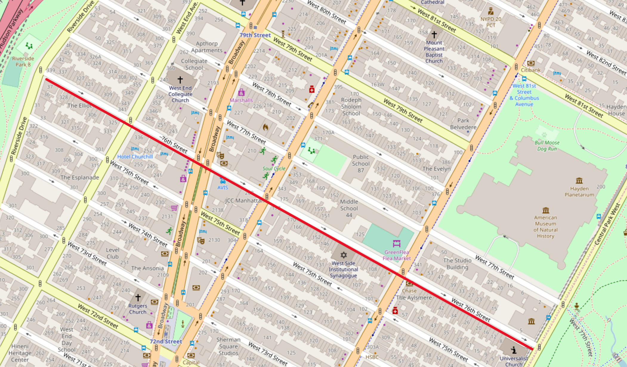
The entirety of West 76th Street starts at Riverside Drive and ends at Central Park West (see red line on map above). It is important to note that when makes a query for a full street, the 'onStreet' and 'borough' paramters are required.


Response Parameters

Below is a list of response parameters that may be returned in the response for the address search function in LocateNYC. Most of these parameters are derived from the NYC Geosupport software. Some of the parameters are returned from LocateNYC software only.


ALTERNATE LOW AND HIGH HOUSE NUMBERS
Parameter Name:
Geosupport Parameter Name: ALTERNATE LOW AND HIGH HOUSE NUMBERS
Geosupport Functions: 3C
Field Length: See HOUSE NUMBER
Field Format: See HOUSE NUMBER
Field Status: Not Implemented
Description: These two fields are non-blank only if this blockface has addresses of both parities (the parity of a number is its attribute of being odd or even). Such a blockface is said to have ‘continuous parity’. If the blockface has continuous parity, the Continuous Parity Indicator is non-blank, the Low and High House Number fields contain the address range for one parity, and the Alternate Low and High House Number fields contain the address range for the other parity. (Which parity is in which set of house number fields is unpredictable.)


ALTERNATIVE BOROUGH FLAG
Parameter Name: alternativeBoroughFlag
Geosupport Parameter Name: ALTERNATIVE BOROUGH FLAG
Geosupport Functions: 1,1A,1B,1E,2,3,3C,3S (COW Only),BL,BN
Field Length: 1
Field Format: 1 byte
Field Status: Active
Description: This flag indicates either that the input address is in Marble Hill or Rikers Island and the alternative (rather than the legal) borough was specified (see UPG Chapter V.7), or that the input address is on Ruby Street in Brooklyn but it was specified using the alternative (Queens) street name 75 Street (see UPG Chapter V.8). This field was also known as the Marble Hill / Rikers Island Flag.
Coded Values:
Code Meaning
C Ruby Street address specified using 75 Street
M Marble Hill address with Bronx specified
R Rikers Island address with Queens specified


ASSEMBLY DISTRICT
Parameter Name: assemblyDistrict
Geosupport Parameter Name: ASSEMBLY DISTRICT
Geosupport Functions: 1E,2 (COW Only),3 (COW Only),3C (COW Only)
Field Length: 2
Field Format: 2 bytes. RJZF
Field Status: Active
Description: A district of the lower house of the New York State legislature. Consists of an aggregation of Election Districts


ATOMIC POLYGON
Parameter Name: atomicPolygon
Geosupport Parameter Name: ATOMIC POLYGON
Geosupport Functions: 1,1B,1E,3 (MSW: Long WA2),3 (COW Only),3C
Field Length: 3
Field Format: 3 bytes RJZF
Field Status: Not Implemented
Description: An atomic polygon is an un-subdivided polygon . Atomic polygons are created based on the New York City CSCL (Citywide Street Centerline) database. Atomic polygons are numbered uniquely within census tract.


BOROUGH CODE
Parameter Name: bblBoroughCode
Geosupport Parameter Name: BOROUGH CODE
Geosupport Functions: All
Field Length: 1
Field Format: 1 byte. Numeric.
Field Status: Active
Description: The first 6 bytes of the standard BBL consists of the 1-byte borough code followed by the 5-byte tax block field, which contains the tax block value right-justified and zero-filled. The last 4 bytes of the standard BBL is the standard tax lot field, which contains the tax lot value right-justified and zero-filled. See Chapter VI.8. The BBL (‘borough-block-and-lot’) identifies a parcel of real property in New York City, called a tax lot. The BBL is composed of the concatenation of the Borough Code, Tax Block and Tax Lot. If the property is a condominium (indicated by the Condominium Flag), the WA2 BBL field contains the billing BBL of the condominium (see Chapter VI.4).
Coded Values:
Code Meaning
1 MANHATTAN
2 BRONX
3 BROOKLYN
4 QUEENS
5 STATEN IS


TAX BLOCK
Parameter Name: bblTaxBlock
Geosupport Parameter Name: TAX BLOCK
Geosupport Functions: All
Field Length: 5
Field Format: 5 bytes
Field Status: Active
Description: The first 6 bytes of the standard BBL consists of the 1-byte borough code followed by the 5-byte tax block field, which contains the tax block value right-justified and zero-filled. The last 4 bytes of the standard BBL is the standard tax lot field, which contains the tax lot value right-justified and zero-filled. See Chapter VI.8. The BBL (‘borough-block-and-lot’) identifies a parcel of real property in New York City, called a tax lot. The BBL is composed of the concatenation of the Borough Code, Tax Block and Tax Lot. If the property is a condominium (indicated by the Condominium Flag), the WA2 BBL field contains the billing BBL of the condominium (see Chapter VI.4).


TAX LOT
Parameter Name: bblTaxLot
Geosupport Parameter Name: TAX LOT
Geosupport Functions: All
Field Length: 4
Field Format: 4 bytes
Field Status: Active
Description: The first 6 bytes of the standard BBL consists of the 1-byte borough code followed by the 5-byte tax block field, which contains the tax block value right-justified and zero-filled. The last 4 bytes of the standard BBL is the standard tax lot field, which contains the tax lot value right-justified and zero-filled. See Chapter VI.8. The BBL (‘borough-block-and-lot’) identifies a parcel of real property in New York City, called a tax lot. The BBL is composed of the concatenation of the Borough Code, Tax Block and Tax Lot. If the property is a condominium (indicated by the Condominium Flag), the WA2 BBL field contains the billing BBL of the condominium (see Chapter VI.4).


BIKE LANE
Parameter Name: bikeLane
Geosupport Parameter Name: BIKE LANE
Geosupport Functions: 1 Extended,1B,1E Extended,3 Extended,3C Extended
Field Length: 1
Field Format: 1 byte
Field Status: Active
Description: As of Release 16D, Bike Lane has 11 codes, instead of 7. A new two-byte field, BIKE LANE 2, is being introduced. The original one-byte Bike Lane field still exists to give users a chance to update their applications. In the one-byte Bike Lane field, the value ‘A’ will appear when the new code is ‘10’, and the value ‘B’ will appear when the new code is ‘11’. We recommend that users update their applications to refer to the new Bike Lane-2 since the one-byte Bike Lane field will be deleted in a later release.
Coded Values:
Code Meaning
1 Class I. Separated Greenway
2 Class II. Striped Bike Lane
3 Class III. Signed Bicycle Route
4 Links. Connecting Segments
5 Combination of Class I and II
6 Combination of Class II and III
7 Step streets, bridge stairs, etc.
8 Combination of Class I and III
9 Combination of Class II and I
A Combination of Class III and I
B Combination of Class III and II


BIKE LANE 2
Parameter Name: bikeLane2
Geosupport Parameter Name: BIKE LANE 2
Geosupport Functions: 1 Extended,1B,1E Extended,3 Extended,3C Extended
Field Length: 2
Field Format: 2 bytes, RJBF
Field Status: Not Implemented
Description: Defines which street segments are part of the bicycle network as defined by the Department of Transportation. Note: As of Geosupport Version 16.4, Bike Lane 2 is being introduced to replace Bike Lane
Coded Values:
Code Meaning
1 Class I. Separated Greenway
2 Class II. Striped Bike Lane
3 Class III. Signed Bicycle Route
4 Links. Connecting Segments
5 Combination of Class I and II
6 Combination of Class II and III
7 Step streets, bridge stairs, etc.
8 Combination of Class I and III
9 Combination of Class II and I
10 Combination of Class III and I
11 Combination of Class III and II


BIKE TRAFFIC DIRECTION
Parameter Name: bikeTrafficDirection
Geosupport Parameter Name: BIKE TRAFFIC DIRECTION
Geosupport Functions: 1 Extended,1B,1E Extended,3 Extended,3C Extended
Field Length: 2
Field Format: 2 bytes, RJBF
Field Status: Not Implemented
Description: Defines the traffic direction of the bike lanes on a segment.
Coded Values:
Code Meaning
Blank No bike lane. No bike lane exists at this segment
FT FROM node to TO node. Bike traffic flows with the segment’s logical direction, i.e. from the FROM node to the TO node.
TF TO node to FROM node. Bike traffic flows against the segment’s logical direction, i.e. from the TO node to the FROM node.
TW Two-Way. Bikes travel in both directions.


BLOCKFACE ID
Parameter Name: blockfaceId
Geosupport Parameter Name: BLOCKFACE ID
Geosupport Functions: 1 Extended,1B,1E Extended,3 Extended,3C Extended
Field Length: 10
Field Format: 10 bytes. RJZF
Field Status: Active
Description: Left Blockface ID is a ten digit number identifying the block face on the left hand side of a segment. Correspondingly, Right Blockface ID identifies the block face on the right hand side of a segment. Block Face is defined as one continuous side of a physical block that is intersected on that side by two other physical through streets. Blockface IDs were established by DoITT’s consultants working on the planimetric feature classes for NYC and are not maintained by the Department of City Planning.


BROWSE FLAG
Parameter Name: browseFlag
Geosupport Parameter Name: BROWSE FLAG
Geosupport Functions: 1,1A,1B,1E,1N,2,3,3C,BB,BF
Field Length: 1
Field Format: 1 byte. Alphabetic
Field Status: Not Implemented
Description: The Browse Flag allows users to request the return of primary or principal output street names and street codes (for Functions 1, 1A, 1B, 1E, 1N, 2, 3, 3C and AP). The Browse Flag also allows users to request the return of preferred output street names and street codes (for Functions 1, 1A, 1B. 1E, 2, 3, 3C and AP).
Coded Values:
Code Meaning
Blank All streets or normalized input street
P Primary streets
F Principal streets
R Preferred street


CENSUS BLOCK 2000
Parameter Name: censusBlock2000
Geosupport Parameter Name: CENSUS BLOCK 2000
Geosupport Functions: 1,1E (MSW: Long WA2 Only),1,1E(COW),2,3 (MSW: Long WA2 Only),3(COW),3C
Field Length: 4
Field Format: 4 bytes, numeric
Field Status: Active
Description: When appended by the CENSUS BLOCK SUFFIX, this area is the smallest geographic area defined by the U.S. Census Bureau for tabulating the census. Generally (but not always) corresponds to a physical city block. Each census block is numbered uniquely within its census tract.


CENSUS BLOCK 2010
Parameter Name: censusBlock2010
Geosupport Parameter Name: CENSUS BLOCK 2010
Geosupport Functions: 1,1E (MSW: for 2010 - Regular WA2),1,1E(COW),2,3 (MSW: Long WA2 Only),3(COW),3C
Field Length: 4
Field Format: 4 bytes, numeric
Field Status: Active
Description: When appended by the CENSUS BLOCK SUFFIX, this area is the smallest geographic area defined by the U.S. Census Bureau for tabulating the census. Generally (but not always) corresponds to a physical city block. Each census block is numbered uniquely within its census tract.


CENSUS TRACT 1990
Parameter Name: censusTract1990
Geosupport Parameter Name: CENSUS TRACT 1990
Geosupport Functions: 1,1E,1B,2,3 (MSW: 2010 - Regular WA2; 2000 - Long WA2 Only),3(COW),3C
Field Length: 6
Field Format: 6 bytes, consisting of numeric 4-digit root followed by numeric 2-digit suffix. The root subfield is RJBF and the suffix subfield is RJZF if any. If the tract number contains no suffix, then the suffix subfield is blank.
Field Status: Active
Description: Geographic area defined by the U.S. Census Bureau for the various decennial censuses. Census tracts for a particular census year are numbered uniquely within borough.


CENSUS TRACT 2000
Parameter Name: censusTract2000
Geosupport Parameter Name: CENSUS TRACT 2000
Geosupport Functions: 1,1E,1B,2,3 (MSW: 2010 - Regular WA2; 2000 - Long WA2 Only),3(COW),3C
Field Length: 6
Field Format: 6 bytes, consisting of numeric 4-digit root followed by numeric 2-digit suffix. The root subfield is RJBF and the suffix subfield is RJZF if any. If the tract number contains no suffix, then the suffix subfield is blank.
Field Status: Active
Description: Geographic area defined by the U.S. Census Bureau for the various decennial censuses. Census tracts for a particular census year are numbered uniquely within borough.


CENSUS TRACT 2010
Parameter Name: censusTract2010
Geosupport Parameter Name: CENSUS TRACT 2010
Geosupport Functions: 1,1E,1B,2,3 (MSW: 2010 - Regular WA2; 2000 - Long WA2 Only),3(COW),3C
Field Length: 6
Field Format: 6 bytes, consisting of numeric 4-digit root followed by numeric 2-digit suffix. The root subfield is RJBF and the suffix subfield is RJZF if any. If the tract number contains no suffix, then the suffix subfield is blank.
Field Status: Active
Description: Geographic area defined by the U.S. Census Bureau for the various decennial censuses. Census tracts for a particular census year are numbered uniquely within borough.


COINCIDENT SEGMENT COUNT
Parameter Name: coincidentSegmentCount
Geosupport Parameter Name: COINCIDENT SEGMENT COUNT
Geosupport Functions: 1,1E,3,3C
Field Length: 1
Field Format: 1 byte, numeric
Field Status: Active
Description: The Coincident Segment Count indicates the situation where one road is above another road. Most streets, such as Broadway in Manhattan have a value of ‘1’ in the Coincident Segment Count. However, there are a few streets where the Coincident Segment Count is greater than one. An example of this is Third Avenue and the Gowanus Expressway in Brooklyn. The Gowanus Expressway is above Third Avenue from about 18th Street until 63rd Street. For these segments, the Coincident Segment Count is ‘2’.


COMMUNITY DISTRICT (CD)
Parameter Name: communityDistrict
Geosupport Parameter Name: COMMUNITY DISTRICT (CD)
Geosupport Functions: 1,1E,2,3,3C,1B (COW)
Field Length: 3
Field Format: 3 bytes. Numeric. The first byte is the Community District Borough Code, and the second and third bytes are the Community District Number, RJZF.
Field Status: Active
Description: There are 59 community districts in the City of New York, as well as 12 Joint Interest Areas (JIAs). The JIAs are major parks and airports that are not contained within any CD. Examples are Central Park, Van Cortlandt Park, LaGuardia and JFK Airports. The JIAs are the numerically highest items in each borough.
Coded Values:
Code Meaning
101-112 Manhattan except Marble Hill
164 Central Park
201-212 Bronx except Rikers Island (Note: the Marble Hill section of Manhattan is in Bronx CDs 7 and 8)
226 Van Cortlandt Park
227 Bronx Park
228 Pelham Bay Park
301-318 Brooklyn
355 Prospect Park
356 Brooklyn Gateway National Recreational Area
401-414 Queens (Note: the Rikers Island section of the Bronx is in Queens CD 1)
480 LaGuardia Airport
481 Flushing Meadows - Corona Park
482 Forest Park
483 JFK International Airport
484 Queens Gateway National Recreational Area
501-503 Staten Island
595 Staten Island Gateway National Recreational Area


COMMUNITY DISTRICT (CD) BOROUGH CODE
Parameter Name: communityDistrictBoroughCode
Geosupport Parameter Name: COMMUNITY DISTRICT (CD) BOROUGH CODE
Geosupport Functions: 1,1E,2,3,3C,1B (COW)
Field Length: 1
Field Format: 1 byte.
Field Status: Active
Description: Borough code.


COMMUNITY DISTRICT (CD) NUMBER
Parameter Name: communityDistrictNumber
Geosupport Parameter Name: COMMUNITY DISTRICT (CD) NUMBER
Geosupport Functions: 1,1E,2,3,3C,1B (COW)
Field Length: 2
Field Format: 2 byte.
Field Status: Active
Description: See COMMUNITY DISTRICT. Last two digits of CD.


SCHOOL DISTRICT
Parameter Name: communitySchoolDistrict
Geosupport Parameter Name: SCHOOL DISTRICT
Geosupport Functions: 1,1E,2,3,3C,1B (COW)
Field Length: 2
Field Format: 2 bytes.
Field Status: Active
Description: School district code.


COMPASS DIRECTION
Parameter Name: compassDirection
Geosupport Parameter Name: COMPASS DIRECTION
Geosupport Functions: 2,3C,3S
Field Length: 1
Field Format: 1 byte
Field Status: Active
Description: In the case of Function 2, the compass direction identifies, for a pair of input streets that intersect at two distinct locations, which of those two intersections is to be processed. (See Chapter VII.2) In the case of Function 3C, the compass direction identifies which side of the street is to be processed. (See Section VII.5) In the case of Function 3S, if the ‘on’ street intersects the first cross street at two distinct locations, the compass direction identifies which of those two intersections is to be processed. (See Chapter VII.6)


COMPASS DIRECTION FOR 2nd INTERSECTION
Parameter Name: compassDirectionIntersection2
Geosupport Parameter Name: COMPASS DIRECTION FOR 2nd INTERSECTION
Geosupport Functions: 3S
Field Length: 1
Field Format: 1 byte
Field Status: Not Implemented
Description: If the ‘on’ street intersects the second cross street at two distinct locations, this compass direction identifies which of those two intersections is to be processed. (See Chapter VII.6)


CONTINUOUS PARITY INDICATOR
Parameter Name: continuousParityIndicator
Geosupport Parameter Name: CONTINUOUS PARITY INDICATOR
Geosupport Functions: 1,1B,1E,3,3C
Field Length: 1
Field Format: 1 byte
Field Status: Active
Description: An 'address range' is a sequence of house numbers along an 'on' street between (and including) a Low House Number and a High House Number. Every address range has one of three possible parities: odd, even or continuous. An address range of odd parity consists of all odd house numbers along the 'on' street between the Low and High House Numbers. An even-parity range consists of all even house numbers between the Low and High House Numbers. A continuous-parity range consists of all house numbers (both even and odd) between the Low and High House Numbers. Most New York City block faces contain an address range that is either of even or odd parity. However, some block faces have a continuous-parity address range, usually where the opposite side of the street is non-addressable because it is a park, a body of water, etc. Some examples of the continuous parity case in Manhattan are Central Park West (the east side of the street runs along Central Park and is non-addressable, while the west side has both odd and even addresses); Riverside Drive; and the portion of Fifth Avenue that runs alongside Central Park. If a New York City block face has a continuous parity address range, Geosupport represents this range as two separate ranges, an odd-parity range and an even-parity range. The practical effect of this depends on the Geosupport function. For Functions 1 and 1E, if an input address lies on a continuous-parity block face, only the range (i.e., the Low and High House Numbers) whose parity is the same as that of the input address is returned in WA2. For Function 3, if an input street segment contains a continuous parity address range, both the odd and the even ranges are returned, in the WA2 fields called Left Low House Number and Left High House Number for the range of one parity, and in the fields Right Low and High House Numbers for the range of the other parity; note that in this case, in reality both the odd and the even ranges are on the same side of the street, even though they are returned in fields called 'left' and 'right'. For Function 3C, if an input block face is on a street segment containing a continuous parity address range (regardless of whether the input block face is on the addressable or the non-addressable side of the segment), both the odd and the even ranges are returned, in the WA2 fields called Low House Number and High House Number for the range of one parity, and in the fields Alternate Low House Number and Alternate High House Number for the range of the other parity. The field Continuous Parity Indicator indicates, for Functions 1, 1B, 1E, 3 and 3C, whether the street segment containing or corresponding to the user input is of the continuous parity type, and if so, which side of the segment is addressable.
Coded Values:
Code Meaning
Blank The street segment does not have a continuous parity address range
L or R The street segment has continuous parity. In this case, the Continuous Parity Indicator indicates which side of the street segment, the left or the right, is addressable. (Left and right are specified with respect to the direction of increasing addresses along the segment)


COUNTY BOUNDARY INDICATOR
Parameter Name: countyBoundaryIndicator
Geosupport Parameter Name: COUNTY BOUNDARY INDICATOR
Geosupport Functions: 3,3C
Field Length: 1
Field Format: 1 byte
Field Status: Active
Description: This field is non-blank when the street segment lies along a borough boundary. The value of this field indicates which side of the segment is out of borough.
Coded Values:
Code Meaning
L Left side of segment is out of borough
R Right side of segment is out of borough
Blank Neither side is out of borough


CROSS STREET NAMES FLAG (a.k.a. EXPANDED FORMAT FLAG)
Parameter Name: crossStreetNamesFlag
Geosupport Parameter Name: CROSS STREET NAMES FLAG (a.k.a. EXPANDED FORMAT FLAG)
Geosupport Functions: 1,1E,2,3,3C,1B (COW)
Field Length: 1
Field Format: 1 byte
Field Status: Active
Description: This field is non-blank when the street segment lies along a borough boundary. The value of this field indicates which side of the segment is out of borough.
Coded Values:
Code Meaning
L Left side of segment is out of borough
R Right side of segment is out of borough
Blank Neither side is out of borough


CROSS STREET REVERSAL FLAG
Parameter Name: crossStreetReversalFlag
Geosupport Parameter Name: CROSS STREET REVERSAL FLAG
Geosupport Functions: 3,3C
Field Length: 1
Field Format: 1 byte
Field Status: Active
Description: This flag indicates the relationship between the order in which the user specified the input cross streets and the direction of increasing addresses along the ‘on’ street.
Coded Values:
Code Meaning
R The direction from Street Name 2 to Street Name 3 is opposite to the direction of increasing addresses
Blank The direction from Street Name 2 to Street Name 3 (the two input cross street fields) conforms to the direction of increasing addresses


CURVE FLAG
Parameter Name: curveFlag
Geosupport Parameter Name: CURVE FLAG
Geosupport Functions: 1,1E,3,3C,1B (COW)
Field Length: 1
Field Format: 1 byte character
Field Status: Active
Description: This flag indicates whether the given geographic feature segment is in reality curved. If so, the curve may be an arc of a circle or an irregular curve. When the segment specified by the input data is an arc of a circle, Functions 1 and 1E return Spatial Coordinates that are positioned relative to this arc rather than to the segment’s chord (the imaginary straight line joining the curved feature’s endpoints). When the segment specified by the input data is an irregular curve, Functions 1 and 1E return blanks in the Spatial Coordinate fields (q.v.), and issue a warning with Reason Code value ‘P’. In the case of Functions 3 and 3C, if the input data define a street stretch encompassing more than one segment (because of a T-intersection or bend), the Curve Flag is set ‘on’ (non-blank) if at least one of the constituent segments of the stretch is curved. See also discussion of Segment Length.
Coded Values:
Code Meaning
I Segment is an irregular curve, i.e., it is curved but it is not an arc of a circle
L Segment is an arc of a circle on the left side of the line joining the segment’s FROM and TO nodes
R Segment is an arc of a circle on the right side of the line joining the segment’s FROM and TO nodes
Blank Segment is not curved


DCP PREFERRED LGC
Parameter Name: dcpPreferredLgc
Geosupport Parameter Name: DCP PREFERRED LGC
Geosupport Functions: 1,1A and BL (regular WA2 only),2,3,3C,BN
Field Length: 2
Field Format: 2 bytes RJZF
Field Status: Active
Description: Identifies the local group of street names designated by the Department of City Planning as ‘preferred’ for display purposes for a specific location on a street.


DEPARTMENT OF SANITATION (DSNY) SNOW PRIORITY CODE
Parameter Name: dsnySnowPriorityCode
Geosupport Parameter Name: DEPARTMENT OF SANITATION (DSNY) SNOW PRIORITY CODE
Geosupport Functions: 1/1E,1/1E Extended,1B,3,3 Extended,3C,3C Extended
Field Length: 1
Field Format: 1 byte character
Field Status: Not Implemented
Description: DSNY (Department of Sanitation) Snow Priority code is used during snow emergencies. It helps DSNY to determine the snow removal schedule, routes and resources needed. The DSNY (Department of Sanitation) Snow Priority indicates the priority of the street with respect to snow removal. New snow priority codes were assigned with Version 16.4 The snow priority codes are as follows:
Coded Values:
Code Meaning
C Critical. These routes are comprised of highways (main beds, entrances, exits interchanges), arterial roadways, main travel thoroughfares (single lane and multi-lane), bus routes, that contain emergency services & first responder facilities (Hospitals, EMS, FDNY, NYPD) and schools.
S Sector. Designed to encompass all streets that are not classified as Critical Streets and are wide enough to accommodate a full size DSNY collection truck with a plow attached.
H Haulster. Designed to service dead ends and streets that cannot be serviced with a collection truck or salt spreader with a plow attached due to narrow street width or tight turning radius (either entering or exiting the street).
V Non-DSNY Street (unchanged)


DOGLEG FLAG
Parameter Name: doglegFlag
Geosupport Parameter Name: DOGLEG FLAG
Geosupport Functions: 3
Field Length: 1
Field Format: 1 byte
Field Status: Active
Description: A dogleg is a street configuration in which a street has a displacement or offset as it crosses another street. A non-blank value in the Dogleg Flag indicates that at least one of the cross streets forms a dogleg as it crosses the ‘on’ street, in such a way that at least one side of the ‘on’ street has a blockface encompassing more than one segment. When Function 3 returns a non-blank value in this flag, the work area represents the ‘innermost’ segment of the dogleg configuration. The Dogleg Flag value indicates which side or sides of the street has (or have) the long blockface(s). A Function 3C call will return information on the long blockface when the user input data specifies a side of a street where there is a long blockface formed by a dogleg or doglegs. The Dogleg Flag will not be set in response to a function 3C call.
Coded Values:
Code Meaning
B Both sides of the ‘on’ street have long blockfaces formed by doglegs. This can only occur if both cross streets form doglegs as they cross the ‘on’ street.
L The left side of the street has a long blockface formed by a dogleg
R The right side of the street has a long blockface formed by a dogleg
Blank Not a dogleg


DOT STREET LIGHT CONTRACTOR AREA
Parameter Name: dotStreetLightContractorArea
Geosupport Parameter Name: DOT STREET LIGHT CONTRACTOR AREA
Geosupport Functions: 1,1E,2,3,3C,1B (COW)
Field Length: 1
Field Format: 1 byte
Field Status: Active
Description: Depatment of Transportation street light contractor service areas
Coded Values:
Code Meaning
1 Street lights serviced by Manhattan contractors
2 Street lights serviced by Bronx contractors
3 Street lights serviced by Brooklyn contractors
4 Street lights serviced by Queens contractors
5 Street lights serviced by Staten Island contractors
X Street light is located on the Brooklyn, Queens boundary
N Street light is located in one borough, but serviced by a different borough


DYNAMIC BLOCK (will be replaced by ATOMIC POLYGON)
Parameter Name: dynamicBlock
Geosupport Parameter Name: DYNAMIC BLOCK (will be replaced by ATOMIC POLYGON)
Geosupport Functions: 1,1B,1E,3 (MSW: Long WA2),3 (COW Only),3C
Field Length: 3
Field Format: 3 bytes RJZF
Field Status: Active
Description: An atomic polygon is an un-subdivided polygon . Atomic polygons are created based on the New York City CSCL (Citywide Street Centerline) database. Atomic polygons are numbered uniquely within census tract.


ELECTION DISTRICT (ED)
Parameter Name: electionDistrict
Geosupport Parameter Name: ELECTION DISTRICT (ED)
Geosupport Functions: 1E,3 (COW only),3C (COW only),1B (COW only)
Field Length: 3
Field Format: 3 bytes
Field Status: Active
Description: A set of districts defined by the NYC Board of Elections to conduct elections. There are approximately 6,000 Election Districts (EDs) in NYC. Each ED is numbered uniquely within its Assembly District. All of NYC’s higher-level political districts, namely Assembly Districts, City Council Districts, Municipal Court Districts, Congressional Districts and State Senatorial Districts, are defined as aggregates of Eds.


FACE CODE
Parameter Name: faceCode
Geosupport Parameter Name: FACE CODE
Geosupport Functions: 1,1E,3,3C,1B (COW only)
Field Length: 4
Field Format: 4 bytes Numeric
Field Status: Not Implemented
Description: A Face Code is assigned to each linear geographic feature represented in the LION file. These consist of streets and certain non-street features, such as census boundaries, shorelines and railroad tracks. Face Codes serve as part of LION keys, which identify a unique LION record. Face Code values are assigned uniquely within borough.


FEATURE TYPE CODE
Parameter Name: featureTypeCode
Geosupport Parameter Name: FEATURE TYPE CODE
Geosupport Functions: 1,1E,3,3C,1B (COW only)
Field Length: 1
Field Format: 1 byte
Field Status: Active
Description: Identifies the type of geographic feature represented by the work area
Coded Values:
Code Meaning
1 Railroad
2 Shoreline
3 Census block boundary without physical existence
4 Other non-street feature
5 ‘Paper street’, i.e., a public street that is legally ‘mapped’ but does not exist physically
6 Private street that exists physically
7 Physically nonexistent district boundary, other than a type ‘3’ feature (see above)
8 Physical Boundary such as a cemetery wall
9 Paper street that coincides with a non-physical boundary such as a Census block
C CCO (Corporation Council Opinion). Street dedicated for public use (See Glossary)
W Path, non-vehicular, addressable
Blank Public street that exists physically, other than a type ‘W’ feature


FEDERAL CLASSIFICATION CODE
Parameter Name: federalClassificationCode
Geosupport Parameter Name: FEDERAL CLASSIFICATION CODE
Geosupport Functions: All
Field Length: 2
Field Format: 2 bytes
Field Status: Active
Description: unknown


FIRE BATTALION
Parameter Name: fireBattalion
Geosupport Parameter Name: FIRE BATTALION
Geosupport Functions: 1,1E,2,3 (MSW: Long WA2),3 (COW),3C,1B (COW only)
Field Length: 2
Field Format: 2 bytes
Field Status: Active
Description: An administrative fire district composed of Fire Companies.


FIRE COMPANY NUMBER
Parameter Name: fireCompanyNumber
Geosupport Parameter Name: FIRE COMPANY NUMBER
Geosupport Functions: 1,1E,2,3 (MSW: Long WA2),3 (COW),3C,1B (COW only)
Field Length: 3
Field Format: 3 bytes. Numeric RJZF
Field Status: Active
Description: The smallest kind of administrative fire district defined by the NYC Fire Department. There are three types, indicated by the Fire Company Type: engine companies, Squad and ladder companies.


FIRE COMPANY TYPE
Parameter Name: fireCompanyType
Geosupport Parameter Name: FIRE COMPANY TYPE
Geosupport Functions: 1,1E,2,3 (MSW: Long WA2),3 (COW),3C,1B (COW only)
Field Length: 1
Field Format: 1 byte
Field Status: Active
Description: Fire companies are characterized by the type of apparatus they use to fight fires.
Coded Values:
Code Meaning
E Engine Company
L Ladder Company
Q Fire Squad


FIRE DIVISION
Parameter Name: fireDivision
Geosupport Parameter Name: FIRE DIVISION
Geosupport Functions: 1,1E,2,3 (MSW: Long WA2),3 (COW),3C,1B (COW only)
Field Length: 2
Field Format: 2 bytes
Field Status: Active
Description: An administrative fire district composed of Fire Battalions.


FROM NODE
Parameter Name: fromNode
Geosupport Parameter Name: FROM NODE
Geosupport Functions: 2,3 (COW only),3C (COW Only),3S (COW Only),1B (COW Only)
Field Length: 7
Field Format: 7 bytes. Numeric
Field Status: Active
Description: A node is an endpoint of a geographic feature segment represented in CSCL/LION. Most nodes are points where a feature bends or terminates or where two features intersect in CSCL/LION. Each node has a node ID assigned to it, which is unique in the entire city. Node ID assignments are permanent; if a node is deleted from CSCL, its node ID is retired and is never reassigned to a different node. A Node ID may be used to identify an intersection or the end points of a segment. An end point node is often referred to as a From Node or a To Node.


FROM NODE X COORDINATE
Parameter Name: fromXCoordinate
Geosupport Parameter Name: FROM NODE X COORDINATE
Geosupport Functions: 2,3 (COW only),3C (COW Only),3S (COW Only),1B (COW Only)
Field Length: 7
Field Format: 7 bytes. Numeric
Field Status: Active
Description: X coordinate (in State Plane) of the FROM NODE.


FROM NODE Y COORDINATE
Parameter Name: fromYCoordinate
Geosupport Parameter Name: FROM NODE Y COORDINATE
Geosupport Functions: 2,3 (COW only),3C (COW Only),3S (COW Only),1B (COW Only)
Field Length: 7
Field Format: 7 bytes. Numeric
Field Status: Active
Description: Y coordinate (in State Plane) of the FROM NODE.


GEOSUPPORT FUNCTION CODE
Parameter Name: geosupportFunctionCode
Geosupport Parameter Name: GEOSUPPORT FUNCTION CODE
Geosupport Functions: All
Field Length: 2
Field Format: 2 bytes. Alphanumeric
Field Status: Active
Description: Input argument which names the Geosupport function to be called.
Coded Values:
Code Meaning
1 1
1A 1A
1AX 1AX
1B 1B
2 2
3 3
BL BL
BN BN
DG DG


GEOSUPPORT MESSAGE
Parameter Name: geosupportMessage
Geosupport Parameter Name: GEOSUPPORT MESSAGE
Geosupport Functions: All
Field Length: 80
Field Format: 80 bytes. Alphanumeric
Field Status: Active
Description: Message from the Geosupport system. This may be a warning explanation or an explanation of a failure.


GAP FLAG
Parameter Name: gapFlag
Geosupport Parameter Name: GAP FLAG
Geosupport Functions: 3S
Field Length: 1
Field Format: 1 byte
Field Status: Active
Description:
Coded Values:
Code Meaning
G A gap exists along the ‘on’ street between this intersection and its predecessor
C Real Streets Only have been requested, resulting in segment lengths being ‘Combined’ and one or more nodes being omitted between this intersection and its predecessor in the list (COW Only).
D A dog-leg type gap exists along the ‘on’ street between this intersection and its predecessor
N A new stretch exists.
Blank No gap, i.e., the ‘on’ street connects this intersection with its predecessor in list. The gap flag in the 1st entry in the list is always blank.


GENERATED RECORD FLAG
Parameter Name: generatedRecordFlag
Geosupport Parameter Name: GENERATED RECORD FLAG
Geosupport Functions: 3,3C
Field Length: 1
Field Format: 1 byte
Field Status: Active
Description: This flag indicates that the geography defined by the input ‘on’ street and two cross streets is not a conventional street segment. There are several cases: a segment one of whose cross-features is a pseudo-street name (codes C, D); a street stretch formed by consolidating more than one consecutive LION segment (codes B, L, M, R, S and T); or a segment that is part of such a street stretch (types F, G). If the input data simultaneously satisfy the criteria for a Generated Record Flag value of C or D and for some other value, the flag contains the value other than C or D.
Coded Values:
Code Meaning
B Record has been generated by consolidating several LION segments to represent a stretch of a street where there is a node that is not at an intersection, such as a bending point (or a consecutive sequence of such nodes).
C Record generated because one or both nodes of segment lie on the City Limit (Bronx-Westchester or Queens-Nassau border), but segment itself lies entirely within the City. The cross street list for a node on the City Limit contains the special street code assigned to the pseudo-street name CITY LIMIT in the Bronx or Queens, as appropriate.
D Record has been generated for a dead end segment, i.e. a segment at least one of whose nodes either has no other segments incident at it, or has segments of non-street features only. The cross street list at such a node contains only the special street code assigned to the pseudo-street name DEAD END in the given borough.
F Record represents a segment that is part of a street stretch that either contains a bending point at which there are no cross streets, or the left side of which is the long blockface of a T-intersection or a consecutive sequence of T-intersections.
G Record represents a segment that is part of a street stretch, that either contains a bending point at which there are no cross streets, or the right side of which is the long blockface of a T-intersection or a consecutive sequence of T-intersections.
L Record has been generated to represent the long blockface on the left side of a T-intersection.
M Record has been generated by consolidating two or more LION segments to represent a stretch of a street containing a node or a consecutive sequence of nodes at which the ‘on’ feature intersects with no streets but intersects with more than one type of non-street feature.
R Record has been generated to represent the long blockface on the right side of a T-intersection.
S Record has been generated by consolidating two or more LION segments to represent a stretch of a street containing a node or a consecutive sequence of nodes at which the ‘on’ feature intersects with no streets but intersects with one or more shorelines.
T Record has been generated by consolidating two or more LION segments to represent a stretch of a street containing a node or a consecutive sequence of nodes at which the ‘on’ feature intersects with no streets but intersects with one or more train tracks.


GENERIC ID
Parameter Name: genericId
Geosupport Parameter Name: GENERIC ID
Geosupport Functions: All
Field Length: 9
Field Format: 9 bytes numeric
Field Status: Active
Description: From NYC LION. A unique ID assigned in order to aggregate granular geometry to represent a Generic view of the city's street network. Streets that contain multiple carriageways or roadbeds (such as Queens Boulevard in Queens and Park Ave in Manhattan) are represented by multiple centerlines corresponding to each roadbed as well as an imaginary 'single' generic centerline.


GEOSUPPORT REASON CODE (GRC)
Parameter Name: geosupportReturnCode
Geosupport Parameter Name: GEOSUPPORT REASON CODE (GRC)
Geosupport Functions: All
Field Length: 2
Field Format: 2 bytes
Field Status: Active
Description: Geosupport has an elaborate apparatus to support application problem-handling. There are three output fields in Work Area 1 that are used to inform calling applications of the outcome of each call to Geosupport. These fields are the Geosupport Return Code (GRC), the Reason Code and the Message. A comprehensive list of GRCs, Reason Codes and Messages is contained in UPG Appendix 4.
Coded Values:
Code Meaning
00 indicates unconditionally successful completion
01 indicates a warning condition.
Values other than 00 or 01 signifies unsuccessful completion, or rejection, caused by either a system error or a user error


HEALTH AREA
Parameter Name: healthArea
Geosupport Parameter Name: HEALTH AREA
Geosupport Functions: 1,1E,2,3,3C,1B
Field Length: 4
Field Format: 4 bytes
Field Status: Active
Description: Districts defined by the NYC Department of Health and used to report statistics on births, deaths, communicable diseases etc. Health Areas are aggregates of Census Tracts.


HEALTH CENTER DISTRICT
Parameter Name: healthCenterDistrict
Geosupport Parameter Name: HEALTH CENTER DISTRICT
Geosupport Functions: 1,1E,2 (COW only),3 Extended,3C Extended
Field Length: 2
Field Format: 2 bytes
Field Status: Active
Description: Districts defined by the NYC Department of Health for administrative purposes. Health Center Districts are aggregates of Health Areas.


HOUSE NUMBER (a.k.a. ADDRESS NUMBER)
Parameter Name: houseNumber
Geosupport Parameter Name: HOUSE NUMBER (a.k.a. ADDRESS NUMBER)
Geosupport Functions: 1,1A,1E,3,3C,1B COW only)
Field Length:
Field Format:
Field Status: Active
Description: If the field name indicates the house number is normalized, for MSW it is in HNI format, and for COW it is in HNS format; otherwise, it is in HND format (see Chapter V.2).


HOUSE NUMBER IN
Parameter Name: houseNumberIn
Geosupport Parameter Name: HOUSE NUMBER IN
Geosupport Functions: 1,1A,1E,3,3C,1B COW only)
Field Length:
Field Format:
Field Status: Active
Description: House number input argument in 'display' (HND) format required by address-related functions.


INSTRUCTIONAL REGION
Parameter Name: instructionalRegion
Geosupport Parameter Name: INSTRUCTIONAL REGION
Geosupport Functions: 1,1E,1A,1B,2,3,3C
Field Length: 2
Field Format: 2 bytes
Field Status: Active
Description: The Department of Education has divided the city into Instructional Regions which group together two or more Community School Districts for administrative purposes. (Instructional Regions have also been known as Instructional Divisions.)


INTERIM ASSISTANCE ELIGIBILITY INDICATOR (IAEI) - a.k.a. CD Eligibility Flag
Parameter Name: interimAssistanceEligibilityIndicator
Geosupport Parameter Name: INTERIM ASSISTANCE ELIGIBILITY INDICATOR (IAEI) - a.k.a. CD Eligibility Flag
Geosupport Functions: 1,1E,2 (COW only),3,3C,1B
Field Length: 1
Field Format: 1 byte
Field Status: Active
Description: Indicates whether the input location is in a census tract that meets the U.S. Department of Housing and Urban Development (HUD) criteria to be eligible for Community Development Block Grant (CDBG) funding. A census tract is eligible for CDBG funding if at least 51.00% of the residents are low- and moderate-income persons (less than 80% of the Median Family Income) and 50% of its total floor area must be comprised of residential usage. All other census tracts are ineligible. In Release 19B, the 'CD Eligibility' values were updated to reflect more current data. Updated income data was provided by HUD and residential usage was calculated by the Department of City Planning (DCP) using PLUTO data (18v2.1).
Coded Values:
Code Meaning
E Input location is in a CD-eligible census tract
I Location is not in a CD-eligible census tract
Blank Location is in a census tract, the CD-eligibility status of which is unknown to the Geosupport System.(Note: This is an error condition and should be reported).


LATITUDE
Parameter Name: latitude
Geosupport Parameter Name: LATITUDE
Geosupport Functions: 1/1E Extended,all variations of 1A/BL/BN (viz. Regular, Long and Extended),1B,2W,3 Extended,3C Extended
Field Length: 9
Field Format: 9 bytes
Field Status: Active
Description: Spatial coordinates based on the lines of latitude and longitude. Lines of latitude measure the north-south position between the poles with the equator defined as 0 degrees. Lines of longitude (or meridians) measure the east-west position, with the prime meridian running through Greenwich, England. For NYC, Latitude is always positive and Longitude is always negative. The latitude and longitude of a location are calculated based on the spatial coordinates (x,y) returned for that location. As a result, the latitude and longitude returned by the Address Processing functions (e.g. 1/1E Extended) will be somewhat different from the values returned by Tax Lot and Building processing functions (e.g. 1A/BL/BN). See also SPATIAL COORDINATES and SPATIAL COORDINATES OF THE TAX LOT CENTROID.


LATITUDE INTERNAL LABEL
Parameter Name: latitudeInternalLabel
Geosupport Parameter Name: LATITUDE INTERNAL LABEL
Geosupport Functions: 1/1E Extended,all variations of 1A/BL/BN (viz. Regular, Long and Extended),1B,2W,3 Extended,3C Extended
Field Length: 9
Field Format: 9 bytes
Field Status: Active
Description: Value of internal label Y coordinate converted to decimal degrees. sEE internalLabelCoordinate


LENGTH IN FEET FROM PREVIOUS NODE
Parameter Name: lengthFromPreviousNode
Geosupport Parameter Name: LENGTH IN FEET FROM PREVIOUS NODE
Geosupport Functions: 3S
Field Length: 5
Field Format: MSW: 3 bytes packed; COW: 5 bytes numeric RJZF
Field Status: Active
Description: The length between two nodes.


LION FACE CODE
Parameter Name: lionFaceCode
Geosupport Parameter Name: LION FACE CODE
Geosupport Functions: 1,1E,3,3C,1B (COW only)
Field Length: 4
Field Format: 4 bytes Numeric
Field Status: Active
Description: A LION Face Code is assigned to each linear geographic feature represented in the LION file. These consist of streets and certain non-street features, such as census boundaries, shorelines and railroad tracks. Face Codes serve as part of LION keys, which identify a unique LION record. Face Code values are assigned uniquely within borough.


LION KEY
Parameter Name: lionKey
Geosupport Parameter Name: LION KEY
Geosupport Functions: 1,1E,3,3C,1B (COW only)
Field Length: 10
Field Format: 10 bytes Numeric
Field Status: Active
Description: The LION Key identifies a record in the CSCL file and relates to predecessor file known as LION. It consists of: BOROUGH CODE ( 1 byte), FACE CODE (4 bytes), SEQUENCE NUMBER (5 bytes)


LION NODE ID
Parameter Name: lionNodeNumber
Geosupport Parameter Name: LION NODE ID
Geosupport Functions: 2,3 (COW only),3C (COW Only),3S (COW Only),1B (COW Only)
Field Length: 7
Field Format: 7 bytes Numeric
Field Status: Active
Description: A node is an endpoint of a geographic feature segment represented in CSCL/LION. Most nodes are points where a feature bends or terminates or where two features intersect in CSCL/LION. Each node has a node ID assigned to it, which is unique in the entire city. Node ID assignments are permanent; if a node is deleted from CSCL, its node ID is retired and is never reassigned to a different node. A Node ID may be used to identify an intersection or the end points of a segment. An end point node is often referred to as a From Node or a To Node.


LION SEGMENT ID
Parameter Name: lionSegmentId
Geosupport Parameter Name: LION SEGMENT ID
Geosupport Functions: 1 and 1E (MSW: Long WA2 only),1 and 1E (COW),3,3C,1B (COW only)
Field Length: 7
Field Format: 7 bytes RJZF
Field Status: Active
Description: Identifies, uniquely within the entire city, a geographic feature segment represented in the CSCL/LION file.


LION SEQUENCE NUMBER
Parameter Name: lionSequenceNumber
Geosupport Parameter Name: LION SEQUENCE NUMBER
Geosupport Functions: 1,1E,3,3C,1B (COW only)
Field Length: 5
Field Format: 5 bytes
Field Status: Active
Description: Identifies a CSCL/LION record uniquely within Face Code. Generally,Sequence Numbers are assigned in the geographic order in which the corresponding segments occur along the geographic feature identified by the given face code. The Borough Code, Face Code and Sequence Number concatenated form the LION key, which serves as a unique identifier for one CSCL/LION record.


LIST OF CROSS STREET CODES
Parameter Name: listOfCrossStreetCodes
Geosupport Parameter Name: LIST OF CROSS STREET CODES
Geosupport Functions: 3S
Field Length: 40
Field Format: 40 bytes, numeric, consisting of 5 slots for intersecting B7SCs.
Field Status: Active
Description: For each intersecting street, this is a list of up to five B7SCs, starting, in general (see Note below), with the lowest B7SC, followed by the next lowest, followed by the remaining B7SCs in ascending order. The purpose of the ordering of the first two street codes is to facilitate the ability of users to form consistent keys for geographic retrieval of application data. Note 1: In order to provide the user with the most meaningful information, ‘normal’ streets will be listed first, followed by ‘special’ streets, such as Ramps and Exits. Railroads, Shorelines and Borough Boundaries will appear next, followed by Named Intersections, CITY LIMITs, DEAD ENDs and BENDs. This will occur even if the ‘special’ streets have lower street codes than the ‘normal’. Note 2: To avoid unnecessary listing of BENDs, Function 3S lists a BEND only if the angle of the bend is 60 degrees or more. (Prior to Release 16D, a bend was listed if the angle was 20 degrees or more.) Also, a bend is not included in the list of cross streets when another real street intersects there as well. Note 3: Since Function 3S returns B7SCs, it is now possible for two streets to have the same B5SCs and different B7SCs, e.g. in Brooklyn, at the intersection of Clinton Street with Livingston Street and Aitken Place, Livingston Street and Aitken Place have the same B5SC (3-56530) but different B7SCs (3-56530-01 and 3-56530-02 respectively)


LIST OF CROSS STREETS
Parameter Name: listOfCrossStreets
Geosupport Parameter Name: LIST OF CROSS STREETS
Geosupport Functions: 1/1E Regular, 1/1E Extended (COW),3,3C,1B (COW only)
Field Length: 30
Field Format: 30 bytes, consisting of slots for up to five 6-byte B5SCs. ‘Empty’ slots contain either numeric zeros or blanks.
Field Status: Active
Description: A list of B5SCs, for up to five streets incident upon a delimiting node (endpoint) of a block face or street segment. The number of non-empty list entries is returned in the corresponding WA2 field NUMBER OF CROSS STREETS AT (LOW or HIGH) ADDRESS END. It is possible for the list to be entirely empty. If the node lies on a borough boundary, the list may contain streets from both boroughs. Subject to the space limitation, the list may include the input cross street corresponding to the given node, and may include the pseudo- streets 'City Limit', 'Dead End' and 'Bend'. The inclusion of 'Bend' in the list indicates that the node is a bending point of the 'on' street, not that it is a bending point of a cross street (although that may be true).


LIST OF SEGMENT IDS
Parameter Name: listOfSegmentIDs
Geosupport Parameter Name: LIST OF SEGMENT IDS
Geosupport Functions: 3,3C
Field Length: 500
Field Format: 500 bytes, consisting of a count of segment ids and 70 slots for 7-byte Segment IDs
Field Status: Active
Description: This list is generated only if Auxiliary Segment Switch is set to ‘Y’. See Chapter VII.4 and Appendix13.


LIST OF STREET CODES
Parameter Name: listOfStreetCodes
Geosupport Parameter Name: LIST OF STREET CODES
Geosupport Functions: 1*,2,3*,BB,BF
Field Length: 80
Field Format: 80 bytes, consisting of 10 fields for B7SCs
Field Status: Active
Description: List of borough and 7-byte street codes, corresponding to the LIST OF STREET NAMES. The number of street codes in the list is returned in the WA1 output field NUMBER OF STREET CODES AND STREET NAMES IN LIST.


LIST OF STREET NAMES
Parameter Name: listOfStreetNames
Geosupport Parameter Name: LIST OF STREET NAMES
Geosupport Functions: 1*,2,3*,BB,BF
Field Length: 320
Field Format: 320 bytes, consisting of 10 fields for street names, each 32 bytes.
Field Status: Active
Description: This field is used by several Geosupport features (see below) to return a list of street names. The number of street names in the list is returned in the WA1 output field NUMBER OF STREET CODES AND STREET NAMES IN LIST. The similar names feature uses the List of Street Names to return up to ten street names deemed 'similar' to a rejected input street name (see UPG Section III.5). The browse functions, Functions BB and BF, use the List of Street Names to return up to ten normalized street names in alphabetical order as part of a street name browse (see UPG Section III.7). The local street name validation feature uses the List of Street Names to return up to four locally valid alias street names corresponding to a street name rejected as locally invalid (see UPG Section IV.5). The cross street names feature (see CROSS STREET NAMES FLAG) uses the List of Street Names to return street names corresponding to the street codes in the LIST OF CROSS STREETS (Functions 1, 1B, 1E, 3 and 3C) or the LIST OF INTERSECTING STREETS (Function 2). In the case of Functions 1, 1B, 1E, 3 and 3C, the first five 32-byte street name fields in the List of Street Names are used for the street names corresponding to the street codes in the LIST OF CROSS STREETS AT LOW ADDRESS END; the second five 32-byte street name fields in the List of Street Names are used for the street names corresponding to the street codes in the LIST OF CROSS STREETS AT HIGH ADDRESS END.


LOCAL GROUP CODE
Parameter Name: localGroupCode
Geosupport Parameter Name: LOCAL GROUP CODE
Geosupport Functions: 1*,2,3*,BB,BF
Field Length: 2
Field Format: 2 bytes. Numeric
Field Status: Active
Description: Local street name validity is reflected in the sixth and seventh digits of the 10SC, which constitute the Local Group Code (LGC). Street codes are assigned in such a way that two names for a street have the same LGC value if and only if those names are valid for the same portion (possibly all) of the street. Note that if two names are valid for overlapping portions of a street, or one is valid for a subset of the portion where the other is valid, then those names are in different local groups. In order to be in the same local group, names must be valid for exactly the same portion of the street. Conceptually, the set of all street names for a given street can be viewed as being partitioned into subsets called ?local street name groups?, each group identified by its LGC value and consisting of all the names that are valid for a particular portion (possibly all) of the street. (Most New York City streets only have one local street name group.) A LGC value is meaningful only relative to its B5SC value. The B5SC identifies the street, and the LGC identifies a local street name group for the given street, that is, the group of all names for the given street that are valid for a particular portion (possibly all) of the street. The B5SC concatenated with the LGC, that is, the first eight bytes of the B10SC, constitute the Borough and Seven-Digit Street Code (B7SC). Two street names have the same B7SC value if and only if they are names for the same street (same B5SC value) and are valid for the same portion of the street (same LGC value relative to the given B5SC value). For a detailed discussion of local group codes, street codes, and street names please see UPG Section IV.


LOCATIONAL STATUS OF SEGMENT
Parameter Name: locationalStatusOfSegment
Geosupport Parameter Name: LOCATIONAL STATUS OF SEGMENT
Geosupport Functions: 3,3C
Field Length: 1
Field Format: 1 byte
Field Status: Active
Description: Indicates locational status of segment
Coded Values:
Code Meaning
H Segment internal to a block, but not a Dead End (A Land Hook)
I Dead End Segment
X Tract Boundary Segment (other than borough boundary)
1 Segment bordering Manhattan
2 Segment bordering Bronx
3 Segment bordering Brooklyn
4 Segment bordering Queens
5 Segment bordering Staten Island
9 Segment bordering City Limits


LOCATION TYPE
Parameter Name: locationType
Geosupport Parameter Name: LOCATION TYPE
Geosupport Functions: 3,3C
Field Length: 4
Field Format: 4 bytes
Field Status: Active
Description: For street segment and blockface, indicates where the location is along the street segment.
Coded Values:
Code Meaning
MID X,Y location is at the midpoint of the street segment or blockface
FROM X,Y location is at the beginning node of the streetsegment or blockface (ie crossstreet1 intersection)
TO X,Y location is at the ending node of the streetsegment or blockface (ie crossstreet2 intersection)


LONGITUDE
Parameter Name: longitude
Geosupport Parameter Name: LONGITUDE
Geosupport Functions: 1/1E Extended,all variations of 1A/BL/BN (viz. Regular, Long and Extended),1B,2W,3 Extended,3C Extended
Field Length: 11
Field Format: 11 bytes
Field Status: Active
Description: Spatial coordinates based on the lines of latitude and longitude. Lines of latitude measure the north-south position between the poles with the equator defined as 0 degrees. Lines of longitude (or meridians) measure the east-west position, with the prime meridian running through Greenwich, England. For NYC, Latitude is always positive and Longitude is always negative. The latitude and longitude of a location are calculated based on the spatial coordinates (x,y) returned for that location. As a result, the latitude and longitude returned by the Address Processing functions (e.g. 1/1E Extended) will be somewhat different from the values returned by Tax Lot and Building processing functions (e.g. 1A/BL/BN). See also SPATIAL COORDINATES and SPATIAL COORDINATES OF THE TAX LOT CENTROID.


LONGITUDE INTERNAL LABEL
Parameter Name: longitudeInternalLabel
Geosupport Parameter Name: LONGITUDE INTERNAL LABEL
Geosupport Functions: 1/1E Extended,all variations of 1A/BL/BN (viz. Regular, Long and Extended),1B,2W,3 Extended,3C Extended
Field Length: 11
Field Format: 11 bytes
Field Status: Active
Description: Value of internal label X coordinate converted to decimal degrees. sEE internalLabelCoordinate


MESSAGE
Parameter Name: message
Geosupport Parameter Name: MESSAGE
Geosupport Functions: All
Field Length: 80
Field Format: 80 bytes. Alphanumeric
Field Status: Active
Description: Message from the Geosupport system. This may be a warning explanation or an explanation of a failure.


MARBLE HILL/RIKERS ISLAND FLAG
Parameter Name: mhriFlag
Geosupport Parameter Name: MARBLE HILL/RIKERS ISLAND FLAG
Geosupport Functions: 1,1A,1B,1E,2,3,3C,3S (COW Only),BL,BN
Field Length: 1
Field Format: 1 byte
Field Status: Active
Description: This flag indicates either that the input address is in Marble Hill or Rikers Island and the alternative (rather than the legal) borough was specified (see UPG Chapter V.7), or that the input address is on Ruby Street in Brooklyn but it was specified using the alternative (Queens) street name 75 Street (see UPG Chapter V.8). This field was also known as the Marble Hill / Rikers Island Flag.
Coded Values:
Code Meaning
C Ruby Street address specified using 75 Street
M Marble Hill address with Bronx specified
R Rikers Island address with Queens specified


MODE SWITCH
Parameter Name: modeSwitch
Geosupport Parameter Name: MODE SWITCH
Geosupport Functions: 1,1E,1A,3,3C,BL,BN
Field Length: 1
Field Format: 1 byte
Field Status: Not Implemented
Description: Indicates request for Extended Work Area 2 for the supported functions. These extended work areas contain street names in addition to Street Codes. Users no longer have to make separate D, DG, or DN calls to get the street names. In addition, CSCL data is returned in the extended Work Area 2. See [Appendix 13](/appendices/appendix13/) for the Work Area layouts. Also, see Chapter II.7.
Coded Values:
Code Meaning
X Extended information in Extended WA2 requested
Blank Extended information not requested (default)


NUMBER OF CROSS STREETS
Parameter Name: numberOfCrossStreets
Geosupport Parameter Name: NUMBER OF CROSS STREETS
Geosupport Functions: 1,3C
Field Length: 1
Field Format: 1 byte, containing a numeric digit from 0 to 5.
Field Status: Active
Description: Indicates the number of non-empty entries in the corresponding LIST OF CROSS STREETS.


NUMBER OF STREET CODES AND STREET NAMES IN LIST
Parameter Name: numberOfStreetCodesAndStreetNamesInList
Geosupport Parameter Name: NUMBER OF STREET CODES AND STREET NAMES IN LIST
Geosupport Functions: 1*,2,3*,BB,BF
Field Length: 2
Field Format: 2 bytes, Numeric
Field Status: Active
Description: Indicates the number of street names returned in the LIST OF STREET NAMES, corresponding to the number of street codes returned in the LIST OF STREET CODES.


NUMBER OF STREET NAMES IN LIST
Parameter Name: numberOfStreetNamesInList
Geosupport Parameter Name: NUMBER OF STREET NAMES IN LIST
Geosupport Functions: 1*,2,3*,BB,BF
Field Length: 2
Field Format: 2 bytes, packed decimal
Field Status: Active
Description: Indicates the number of street names returned in the LIST OF STREET NAMES.


NUMBER OF PARKING LANES
Parameter Name: numberOfParkingLanes
Geosupport Parameter Name: NUMBER OF PARKING LANES
Geosupport Functions: 1/1E Extended,1B,3 Extended,3C Extended
Field Length: 2
Field Format: 2 bytes, RJBF.
Field Status: Not Implemented
Description: The number of lanes in a carriageway (roadway) that are reserved for parking of vehicles. The number of parking lanes were determined by DoITT’s consultants working on the planimetric feature classes for NYC.


NUMBER OF TOTAL LANES
Parameter Name: numberOfTotalLanes
Geosupport Parameter Name: NUMBER OF TOTAL LANES
Geosupport Functions: 1/1E Extended,1B,3 Extended,3C Extended
Field Length: 2
Field Format: 2 bytes, RJBF.
Field Status: Not Implemented
Description: The total number of lanes in a carriageway (roadway) including travel lanes and parking lanes. The total number of lanes were determined by DoITT’s consultants working on the planimetric feature classes for NYC.


NUMBER OF TRAVEL LANES
Parameter Name: numberOfTravelLanes
Geosupport Parameter Name: NUMBER OF TRAVEL LANES
Geosupport Functions: 1/1E Extended,1B,3 Extended,3C Extended
Field Length: 2
Field Format: 2 bytes, RJBF.
Field Status: Not Implemented
Description: The number of lanes in a carriageway (roadway) that are designated for the movement of vehicles traveling from one destination to another. The number of travel lanes were determined by DoITT’s consultants working on the planimetric feature classes for NYC.


NEIGHBORHOOD TABULATION AREA (NTA) CODE
Parameter Name: nta
Geosupport Parameter Name: NEIGHBORHOOD TABULATION AREA (NTA) CODE
Geosupport Functions: 1,1 Extended,1E,1E Extended,1B,3,3 Extended,3C,3C Extended
Field Length: 4
Field Format: 4 bytes alphanumeric
Field Status: Active
Description: The Neighborhood Tabulation Areas (NTAs) are aggregations of census tracts that reflect the 2010 Census. The NTAs are assigned a 4-byte code and a 75-byte name. They are used by the Population Division of the Department of City Planning. See [Appendix 16](/appendices/appendix16/) for a description of the NTA’s history and significance. The first two bytes of the NTA code are an alphabetic borough code as follows: MN-Manhattan, BX-Bronx, BK-Brooklyn, QN-Queens, SI-Staten Island. The remaining two bytes are numeric and uniquely define the NTA.


NEIGHBORHOOD TABULATION AREA (NTA) NAME
Parameter Name: ntaName
Geosupport Parameter Name: NEIGHBORHOOD TABULATION AREA (NTA) NAME
Geosupport Functions: 1 Extended,1E Extended,1B,3 Extended,3C Extended
Field Length: 75
Field Format: 75 bytes alphanumeric
Field Status: Active
Description: The Neighborhood Tabulation Areas (NTAs) are aggregations of census tracts that reflect the 2010 Census. The NTAs are assigned a 4-byte code and a 75-byte name. They are used by the Population Division of the Department of City Planning. See [Appendix 16](/appendices/appendix16/) for a description of the NTA’s history and significance. The first two bytes of the NTA code are an alphabetic borough code as follows: MN-Manhattan, BX-Bronx, BK-Brooklyn, QN-Queens, SI-Staten Island. The remaining two bytes are numeric and uniquely define the NTA.


NYPD ID
Parameter Name: nypdId
Geosupport Parameter Name: NYPD ID
Geosupport Functions: All
Field Length: 7
Field Format: 7 bytes numeric
Field Status: Active
Description: From NYC LION. A unique ID assigned for NYPD's use in order to aggregate granular geometry for administrative purposes.


POLICE PATROL BOROUGH COMMAND
Parameter Name: policePatrolBoroughCommand
Geosupport Parameter Name: POLICE PATROL BOROUGH COMMAND
Geosupport Functions: 1,1E,2,3,3C,1B (COW only)
Field Length: 1
Field Format: 1 byte
Field Status: Active
Description: These are sub-borough geographic areas defined by the Police Department. They are composed of Police Precincts.
Coded Values:
Code Meaning
1 Manhattan South
2 Manhattan North
3 Bronx
4 Brooklyn South
5 Brooklyn North
6 Queens North
7 Staten Island
8 Queens South


POLICE PATROL BOROUGH
Parameter Name: policePatrolBorough
Geosupport Parameter Name: POLICE PATROL BOROUGH
Geosupport Functions: 1,1E,2,3,3C,1B (COW only)
Field Length: 1
Field Format: 1 byte
Field Status: Not Implemented
Description: These are sub-borough geographic areas defined by the Police Department. They are composed of Police Precincts.
Coded Values:
Code Meaning
MS Manhattan South
MN Manhattan North
BX Bronx
BS Brooklyn South
BN Brooklyn North
QN Queens North
SI Staten Island
QS Queens South


POLICE PRECINCT
Parameter Name: policePrecinct
Geosupport Parameter Name: POLICE PRECINCT
Geosupport Functions: 1,1E,2,3,3C,1B (COW only)
Field Length: 3
Field Format: 3 bytes. RJZF.
Field Status: Active
Description: Police Patrol Borough Commands are sub-divided into Police Precincts which are defined by the Police Department


POLICE SECTOR
Parameter Name: policeSector
Geosupport Parameter Name: POLICE SECTOR
Geosupport Functions: 1/1E Extended,1B,2,2W,3 Extended,3C Extended
Field Length: 4
Field Format: 4 bytes. RJBF.
Field Status: Not Implemented
Description: In order to support Neighborhood Policing, the NYC Police Department has divided each precinct into four or five fully-staffed Police Sectors. The Police Sectors correspond, as much as possible, to the boundaries of actual established neighborhoods. The Police Sector field consists of the Precinct Number followed by a letter, e.g. 114A.


PUBLIC USE MICRODATA AREA (PUMA) CODE
Parameter Name: pumaCode
Geosupport Parameter Name: PUBLIC USE MICRODATA AREA (PUMA) CODE
Geosupport Functions: 1 Extended,1E Extended,1B,3 Extended,3C Extended
Field Length: 5
Field Format: 5 bytes, RJZF
Field Status: Active
Description: PUMAs (Public Use Microdata Areas) are approximations of New York City's Community Districts which were developed for use with the Census Bureau's Public Use Microdata Samples (PUMS). In order to make the boundaries consistent with PUMAs, NTAs were created using whole census tracts, from the 2010 census, within PUMAs. For more information on the history and significance of NTAs and PUMAs, see Appendix 16. See also NEIGHBORHOOD TABULATION AREA (NTA) CODE


PHYSICAL ID
Parameter Name: physicalId
Geosupport Parameter Name: PHYSICAL ID
Geosupport Functions: All
Field Length: 9
Field Format: 9 bytes numeric
Field Status: Active
Description: From NYC LION. A unique ID assigned in order to aggregate granular geometry to represent a Physical View of the city's street network. In CSCL, segmentation is very granular in order to accommodate many types of physical and non-physical geometry. The Physical ID is a unique number used to identify a physically existing piece of geometry that may or may not be comprised of several Segment IDs. For example, E 28 Street between 2nd Ave and 3rd Ave in Manhattan would have 1 Physical ID although there are 3 segments defining that block face, with 3 separate Segment IDs.


RETURN CODE
Parameter Name: returnCodes
Geosupport Parameter Name: RETURN CODE
Geosupport Functions: 1 Extended,1E Extended,1B,3 Extended,3C Extended
Field Length: 3
Field Format: 2 byte return code optionally followed by 1 byte reason code.
Field Status: Active
Description: Indicates success or failure of all function calls. Also indicates warnings and provides warning message where applicable.


REASON CODE
Parameter Name: reasonCode
Geosupport Parameter Name: REASON CODE
Geosupport Functions: All
Field Length: 1
Field Format: 1 bytes
Field Status: Active
Description: Geosupport has an elaborate apparatus to support application problem-handling. There are three output fields in Work Area 1 that are used to inform calling applications of the outcome of each call to Geosupport. These fields are the Geosupport Return Code (GRC), the Reason Code and the Message. The reason code is provided when a non '00' GRC is returned in order to provide more context to the warning or error condition. A comprehensive list of GRCs, Reason Codes and Messages is contained in UPG Appendix 4.


REAL STREET ONLY FLAG
Parameter Name: realStreetOnlyFlag
Geosupport Parameter Name: REAL STREET ONLY FLAG
Geosupport Functions: 3S
Field Length: 1
Field Format: 1 byte. Alphabetic
Field Status: Active
Description:
Coded Values:
Code Meaning
Blank All streets are returned
R Real streets only (not Bends or Non-Street Features


ROADBED REQUEST SWITCH
Parameter Name: roadbedRequestSwitch
Geosupport Parameter Name: ROADBED REQUEST SWITCH
Geosupport Functions: 1,1E,3S,1B (COW only)
Field Length: 1
Field Format: 1 byte
Field Status: Active
Description: Indicates request for Roadbed information for roads that are divided into two or more roadbeds. If Roadbed information is requested for a street that is not divided, Geosupport returns the generic information. For functions 1 and 1E, the Segment Type Code will indicate the type of information that is being returned. For more information on function 3S see Chapter VII.6.
Coded Values:
Code Meaning
Blank Generic (non-roadbed) information requested (default)
R Roadbed information requested


SCHOOL DISTRICT (previously known as Community School District)
Parameter Name: communitySchoolDistrict
Geosupport Parameter Name: SCHOOL DISTRICT (previously known as Community School District)
Geosupport Functions: 1,1E,2,3,3C,1B (COW)
Field Length: 2
Field Format: 2 bytes.
Field Status: Active
Description: School district code.


SCHOOL DISTRICT (previously known as Community School District)
Parameter Name: segmentAzimuth
Geosupport Parameter Name: SCHOOL DISTRICT (previously known as Community School District)
Geosupport Functions: 3,3C
Field Length: 3
Field Format: 3 bytes.
Field Status: Active
Description: This item represents the direction in which the segment lies on the earth’s surface, expressed as an angle in degrees measured counterclockwise from due east. The segment is considered to be pointing in the direction of increasing addresses, and the azimuth value can range from 0 to 359 degrees, inclusive. For example, a segment pointing due east has an azimuth of 0; one pointing due north has an azimuth of 90; one pointing due west has an azimuth of 180; one pointing halfway between due west and due south (i.e., pointing due southwest) has an azimuth of 225.


SEGMENT LENGTH IN FEET
Parameter Name: segmentLengthInFeet
Geosupport Parameter Name: SEGMENT LENGTH IN FEET
Geosupport Functions: 1,1E,3,3C,1B (COW only)
Field Length: 5
Field Format: 5 bytes numeric
Field Status: Active
Description: Except for curved segments (see Curve Flag), the Segment Length is computed from the Spatial Coordinates of the segment's endpoints, as digitized in the LION file. For curved segments, the Segment Length is computed by summing the lengths of the small straight line segments that approximate the curve in the GIS version of LION; this is a more accurate approximation to the true arc length of the curve than would be the segment's 'secant length', that is, the straight line distance between the curve's extreme endpoints. In the case of Functions 3 and 3C, if the input data define a street stretch encompassing more than one segment (because of a T-intersection or bend), the Segment Length returned is the sum of the lengths of the constituent segments of the stretch. In all cases, the Segment Length has a very approximate level of accuracy only, and should not be used in applications requiring high precision.


SEGMENT ORIENTATION
Parameter Name: segmentOrientation
Geosupport Parameter Name: SEGMENT ORIENTATION
Geosupport Functions: 3,3C
Field Length: 1
Field Format: 1 byte character
Field Status: Active
Description: This item is a set of codes grouping the possible azimuth values of a segment into eight categories. The categories are approximately due north, south, east and west, and the four quadrants of the rectangular coordinate system for segments that do not lie approximately due north, south, east or west. 'Approximately' as used here means 'within 5 degrees'. In Manhattan, all orientation codes are defined with a 30‑degree clockwise shift (i.e., 30 is subtracted from the azimuth value) in order to conform to the conventional concept that the midtown streets and avenues lie due east‑west and due north‑south, respectively. For example, 'approximately due north' means 'within 5 degrees of due north'; for the boroughs other than Manhattan, this corresponds to the range of azimuth values from 85 to 95; in Manhattan, the corresponding azimuth value range is 55 to 65. There is a ninth orientation category, with a code value of ‘U’, meaning Geosupport could not determine the segment’s orientation because of a problem with the segment’s Spatial Coordinates. All occurrences of an orientation code of ‘U’ should be reported to Geographic Systems Section staff.
Coded Values:
Code Meaning
U Orientation is undefined.
E Approximately due east. Manhattan: 325-335, Other Boroughs: 0-5 and 355-359
1 First quadrant, i.e. northeasterly. Manhattan: 336-359, Other Boroughs: 6-84 and and 0-54
N Approximately due north. Manhattan: 55-65, Other Boroughs: 85-95
2 Second quadrant, i.e. northwesterly. Manhattan: 66-144, Other Boroughs: 96-174
W Approximately due west. Manhattan: 145-155, Other Boroughs: 175-185
3 Third quadrant, i.e. southwesterly. Manhattan: 156-234, Other Boroughs: 186-264
S Approximately due south. Manhattan: 235-245, Other Boroughs: 265-275
4 Fourth quadrant, i.e. southeasterly. Manhattan: 246-324, Other Boroughs: 276-354


SEGMENT TYPE CODE
Parameter Name: segmentTypeCode
Geosupport Parameter Name: SEGMENT TYPE CODE
Geosupport Functions: 1,1E,3,3C,1B (COW only)
Field Length: 1
Field Format: 1 byte
Field Status: Active
Description: Indicates type of segment
Coded Values:
Code Meaning
U Undivided
G Generic
B Both Generic and Roadbed
R Roadbed
C Connector
E Exit/Entrance Ramp
T Terminator
F Faux segment (used when a street or ramp physically ends at a roadbed, but connectivity needs to be maintained with the generic segment.)


SIDE OF STREET INDICATOR
Parameter Name: sideOfStreetIndicator
Geosupport Parameter Name: SIDE OF STREET INDICATOR
Geosupport Functions: 1,1E,1A - regular WA2,3C
Field Length: 1
Field Format: 1 byte character
Field Status: Active
Description: This field indicates on which side of the street, left or right, the blockface containing the input address lies. Left and right are defined with respect to the direction of increasing addresses along the ‘on’ street.
Coded Values:
Code Meaning
L Block face is on left side of street with respect to direction of increasing address
R Generic


SPATIAL COORDINATES (See also SPATIAL COORDINATES OF TAX LOT CENTROID)
Parameter Name: spatialCoordinates
Geosupport Parameter Name: SPATIAL COORDINATES (See also SPATIAL COORDINATES OF TAX LOT CENTROID)
Geosupport Functions: 1,1B (blockface information),1E,2,3 Extended,3C Extended,AP (For Function 1A, BL, BN, 1B (property level information) see also SPATIAL COORDINATES OF TAX LOT CENTROID)
Field Length: 7
Field Format: Spatial coordinates consist of two fields, an X Coordinate and a Y Coordinate, each 7 bytes RJZF.
Field Status: Active
Description: Spatial coordinates are a pair of numbers that specify a location on the earth’s surface. Geosupport returns spatial coordinates for an input address (Functions 1, 1B (blockface information), 1E, and AP), intersection (Function 2), and nodes at the end of a blockface (Functions 3 Extended and 3C Extended). Spatial coordinates are often used in conjunction with separate computer mapping and Geographic Information System (GIS) software to generate maps and for spatial analysis, although the Geosupport System does not itself provide users with such capabilities. Note: For Functions 1, 1B (blockface information) and 1E, the spatial coordinates that Geosupport returns are imprecise approximations of real-world locations, and are not appropriate for use in applications that require a high level of spatial accuracy. Spatial coordinates are expressed various geodetic coordinate systems, of which latitude/longitude is a well-known example. The coordinate system that Geosupport uses is known as the State Plane Coordinate (SPC) system. The SPC system is based upon the fact that, in a small enough geographic area, the earth’s surface can be assumed to be flat without introducing a significant error. In the SPC system, each state of the U.S. is subdivided into zones small enough to model as planar areas. In each SPC zone, a Cartesian coordinate system is established, with the X and Y coordinate axes oriented due east and due north, respectively, and the origin selected to be a point well to the southwest of the entire zone. (The origin is so selected to insure that the X and Y coordinates of all points within the zone are positive values.) The SPC zone that New York City is in, and which Geosupport uses, is called the New York-Long Island zone, NAD 83. In the SPC system, one unit of X or Y represents one foot of distance on the ground. A major advantage of the SPC system over other map projection systems is the ease of calculating the distance between two points. In the case of Functions 1, 1B (blockface information) and 1E, if the street segment on which the input address lies is a straight line segment or an arc of a circle, Geosupport computes and returns output spatial coordinates using a complex algorithm, a detailed description of which is beyond the scope of this document. If, however, the input address lies on a irregularly curved geographic feature (see Curve Flag), Functions 1, 1B (blockface information), and 1E return blanks in the spatial coordinate fields. Functions 1, 1B (blockface information), and 1E’s spatial coordinates algorithm produces a point position based on how the input address is prorated with respect to the administrative address range allocated to the entire blockface. In addition, the computed point is positioned slightly set off from the segment, on the side of the street where the input address is located. This offset is graphically desirable and also insures that the point will fall within the interiors of the proper political and administrative district boundary polygons for the given address. The computed point is a rough approximation to the location of the input address, intended to be used only for thematic mapping and other purposes that do not require a high level of spatial accuracy. The spatial coordinates returned by Functions 1/1E/1B (blockface information) for NAPs and Vanity Addresses (see Chapter V.9) were an estimate calculated by Geosupport. As of Version 11.2, Geosupport will use the Citywide Street Centerline file (CSCL) X-Y Coordinates. The CSCL information guarantees that the X-Y coordinates fall within the actual location of the NAP or Vanity Address. In the case of Function 2, the spatial coordinates returned are those of the LION node that corresponds to the input street intersection. Those coordinates represent an approximate center point of the intersection. In the case of Function 3 Extended and Function 3C Extended, the spatial coordinates returned are those of the nodes at the end of the blockface. Those coordinates represent an approximate center point of the intersection. In the case of Function AP, the spatial coordinates returned are those of the Address Point which is within 5 feet of the entrance(s) of the building. In the case of Functions 1A, BL, BN, 1B (property level information),the spatial coordinates returned are those of the Tax Lot Centroid. See SPATIAL COORDINATES OF THE TAX LOT CENTROID.


SPEED LIMIT
Parameter Name: speedLimit
Geosupport Parameter Name: SPEED LIMIT
Geosupport Functions: 1/1E Extended,1B,3/3C Extended
Field Length: 2
Field Format: 2 bytes.
Field Status: Not Implemented
Description: The Speed Limit field contains the speed limit, in miles per hour, of the paved area of the input location. Speed Limit data was provided by the NYC Department of Transportation and currently does not cover the entire city. Additional data will be made available in future releases.


STREET NAME NORMALIZATION FORMAT FLAG
Parameter Name: streetNameNormalizationFormatFlag
Geosupport Parameter Name: STREET NAME NORMALIZATION FORMAT FLAG
Geosupport Functions: 1,1A,1E,1N,2,3,3C,3S,D,DG,DN,1B (COW only)
Field Length: 1
Field Format: 1 byte
Field Status: Active
Description: Specifies the format in which Geosupport is to return output normalized street names. The default is to return street names in the sort format.
Coded Values:
Code Meaning
C Return normalized street names in the compact format
S Return normalized street names in the sort format
Blank Return normalized street names in the sort format


STREET NAME NORMALIZATION LENGTH LIMIT (SNL)
Parameter Name: streetNameNormalizationLengthLimit
Geosupport Parameter Name: STREET NAME NORMALIZATION LENGTH LIMIT (SNL)
Geosupport Functions: WA1 input item,Functions 1,1A,1E,1N,2,3,3C,3S,D,DG,DN,1B (COW only)
Field Length: 2
Field Format: 2 bytes, blank or numeric, either LJBF or RJZF.
Field Status: Active
Description: Specifies the maximum length in bytes within which Geosupport is to normalize street names. The minimum and maximum permissible SNL values are 4 and 32. The default that is in effect if the application does not specify an SNL value is 32


STREET STATUS
Parameter Name: streetStatus
Geosupport Parameter Name: STREET STATUS
Geosupport Functions: All
Field Length: 1
Field Format: 1 bytes, character
Field Status: Active
Description: Currently undocumented. Actively seeking clarification.


STREET WIDTH
Parameter Name: streetWidth
Geosupport Parameter Name: STREET WIDTH
Geosupport Functions: 1/1E Extended,1B,3 Extended,3C Extended
Field Length: 3
Field Format: 3 bytes, RJBF
Field Status: Active
Description: The width, in feet, of the paved area of the street. Street Width contains the width at the narrowest part of the street. If the width is consistent along the street segment then both values are identical.


STREET WIDTH IRREGULAR
Parameter Name: streetWidthIrregular
Geosupport Parameter Name: STREET WIDTH IRREGULAR
Geosupport Functions: 1/1E Extended,1B,3 Extended,3C Extended
Field Length: 1
Field Format: 1
Field Status: Active
Description: Indicates if the street width is irregular.


STREET WIDTH MAXIMUM
Parameter Name: streetWidthMax
Geosupport Parameter Name: STREET WIDTH MAXIMUM
Geosupport Functions: 1/1E Extended,1B,3 Extended,3C Extended
Field Length: 3
Field Format: 3 bytes, RJBF
Field Status: Active
Description: The width, in feet, of the paved area of the street. Street Width Maximum contains the width at the widest part of the street. If the width is consistent along the street segment then both values are identical.


TRAFFIC DIRECTION
Parameter Name: trafficDirection
Geosupport Parameter Name: TRAFFIC DIRECTION
Geosupport Functions: 1/1E Extended,1B,3 Extended,3C Extended
Field Length: 1
Field Format: 1 byte
Field Status: Active
Description:
Coded Values:
Code Meaning
A One way street, traffic flows against the segment’s directionality, i.e., from the segment’s TO node to the FROM node
P Pedestrian path, non-vehicular
T Two‑way street
W One way street, traffic flows with the segment’s directionality, i.e., from the FROM node to the TO node
Blank Non-street feature (or unknown if not a non-street feature)


WORK AREA FORMAT INDICATOR
Parameter Name: workAreaFormatIndicator
Geosupport Parameter Name: WORK AREA FORMAT INDICATOR
Geosupport Functions: All
Field Length: 1
Field Format: 1 byte
Field Status: Active
Description: This indicator specifies which work area layouts are to be used in an API call. Note: This indicator is also known as the Platform Indicator.
Coded Values:
Code Meaning
C The platform-independent work areas known as the Character-Only Work Areas (COWs) are used. These contain no packed decimal fields. For information on using COWs on the mainframe and the differences from the MSWs, see [Appendix 12](/appendices/appendix12/). For the work area layouts of the COWs, see [Appendix 13](/appendices/appendix13/).
Blank The IBM mainframe specific work areas (MSWs) are used. The MSWs contain packed decimal fields. In general, these work areas are the ones described throughout this manual


X COORDINATE
Parameter Name: xCoordinate
Geosupport Parameter Name: X COORDINATE
Geosupport Functions: All
Field Length: 7
Field Format: 7 bytes RJZF. Numeric.
Field Status: Active
Description: X coordinate (longitude) in the State Plane Coordinate system.


Y COORDINATE
Parameter Name: yCoordinate
Geosupport Parameter Name: Y COORDINATE
Geosupport Functions: All
Field Length: 7
Field Format: 7 bytes RJZF. Numeric.
Field Status: Active
Description: Y coordinate (latitude) in the State Plane Coordinate system.


ZIP CODE
Parameter Name: zipCode
Geosupport Parameter Name: ZIP CODE
Geosupport Functions: 1,1A,1E,2,3,3C,1B
Field Length: 5
Field Format: 5 bytes. Numeric.
Field Status: Active
Description: U.S. Postal Service’s 5-digit ZIP code. ZIP code may also be used as input with functions 1, 1A, 1B, and 1E to identify the borough or Duplicate Address Pseudo-Street name (DAPS).


Match_addr
Parameter Name: Match_addr
Geosupport Parameter Name:
Geosupport Functions:
Field Length:
Field Format:
Field Status: Active
Description: Normalized address. Same as FullAddress. This parameter is added for Esri reverseGeocode standardization.


Loc_name
Parameter Name: Loc_name
Geosupport Parameter Name:
Geosupport Functions:
Field Length:
Field Format:
Field Status: Active
Description: LocateNYC locator name. This is the internal locator that was used to locator the coordinates. This parameter is added for Esri reverseGeocode standardization.


Addr_type
Parameter Name: Addr_type
Geosupport Parameter Name:
Geosupport Functions:
Field Length:
Field Format:
Field Status: Active
Description: The type of address that was returned in the reverse geocode. This will be 'PointAddress' if an address point locator was used. It will be 'StreetAddress' if an address interpolation was used. This parameter is added for Esri reverseGeocode standardization.


address_separated
Parameter Name: address_separated
Geosupport Parameter Name:
Geosupport Functions:
Field Length:
Field Format:
Field Status: Active
Description: Comma separated address parts.


Score
Parameter Name: Score
Geosupport Parameter Name:
Geosupport Functions:
Field Length:
Field Format:
Field Status: Active
Description: Match score. Indicates strength of match with 100 being the highest and 0 being the lowest (no match). This parameter is added for Esri reverseGeocode standardization


geoclient_function
Parameter Name: geoclient_function
Geosupport Parameter Name:
Geosupport Functions:
Field Length:
Field Format:
Field Status: Active
Description: Internal LocateNYC code for geoclient function used for address matching.


geoclient_version
Parameter Name: geoclient_version
Geosupport Parameter Name:
Geosupport Functions:
Field Length:
Field Format:
Field Status: Active
Description: NYC Geoclient software version. For more details on Geoclient please visit https://developer.cityofnewyork.us/api/geoclient-api.


geosupport_release
Parameter Name: geosupport_release
Geosupport Parameter Name:
Geosupport Functions:
Field Length:
Field Format:
Field Status: Active
Description: NYC Geosupport software release name


geosupport_release_date
Parameter Name: geosupport_release_date
Geosupport Parameter Name:
Geosupport Functions:
Field Length:
Field Format:
Field Status: Active
Description: NYC Geosupport software release date (approximate to the month)


geosupport_version
Parameter Name: geosupport_version
Geosupport Parameter Name:
Geosupport Functions:
Field Length:
Field Format:
Field Status: Active
Description: NYC Geosupport software release version number


status
Parameter Name: status
Geosupport Parameter Name:
Geosupport Functions:
Field Length:
Field Format:
Field Status: Active
Description: Match status. This parameter is added for Esri reverseGeocode standardization


level
Parameter Name: level
Geosupport Parameter Name:
Geosupport Functions:
Field Length:
Field Format:
Field Status: Active
Description: Match level. This parameter is added for Esri reverseGeocode standardization


address
Parameter Name: address
Geosupport Parameter Name:
Geosupport Functions:
Field Length:
Field Format: Numeric
Field Status: Active
Description: The normalized match address.


wkid
Parameter Name: wkid
Geosupport Parameter Name:
Geosupport Functions:
Field Length:
Field Format: Character
Field Status: Active
Description: This indicates the Projected Coordinate System or the Geographic Coordinate System used to locate geographic features in the map. For a list of projected coordinate systems please see https://developers.arcgis.com/rest/services-reference/projected-coordinate-systems.htm. For a list of geographic coordinate systems please see https://developers.arcgis.com/rest/services-reference/geographic-coordinate-systems.htm


latestWkid
Parameter Name: latestWkid
Geosupport Parameter Name:
Geosupport Functions:
Field Length:
Field Format: Character
Field Status: Active
Description: This indicates the Projected Coordinate System or the Geographic Coordinate System used to locate geographic features in the map. For a list of projected coordinate systems please see https://developers.arcgis.com/rest/services-reference/projected-coordinate-systems.htm. For a list of geographic coordinate systems please see https://developers.arcgis.com/rest/services-reference/geographic-coordinate-systems.htm. Identifies the current wkid value associated with the same spatial reference. For example a WKID of '102100' (Web Mercator) may have a latestWKid of '3857' since '102100' is deprecated.